Nepal,[a] officially the Federal Democratic Republic of Nepal,[b] is a landlocked country in South Asia. It is mainly situated in the Himalayas, but also includes parts of the Indo-Gangetic Plain. It borders the Tibet Autonomous Region of China to the north, and India to the south, east, and west, while it is narrowly separated from Bangladesh by the Siliguri Corridor, and from Bhutan by the Indian state of Sikkim. Nepal has a diverse geography, including fertile plains, subalpine forested hills, and eight of the world's ten tallest mountains, including Mount Everest, the highest point on Earth. Kathmandu is the nation's capital and the largest city. Nepal is a multi-ethnic, multi-lingual, multi-religious and multi-cultural state, with Nepali as the official language.
Federal Democratic Republic of Nepal
सङ्घीय लोकतान्त्रिक गणतन्त्र नेपाल (Nepali)
Saṅghīya Lokatāntrika Gaṇatantra Nepāla
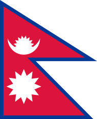
Two united crimson pennants with blue borders, top one containing a stylised symbol for the moon and the bottom one, the sun.
Flag
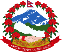
In the background, blue-white snowy himalayas, green forested hills and yellowish fertile plains from top to bottom; in the foreground, two male and female hands joined and a plain white map of Nepal, supported by a wreath of red rhododendrons, seven on each side, with the flag of Nepal at the crest, and at the bottom, the motto of Nepal in Devanagari script
Emblem
Motto: जननी जन्मभूमिश्च स्वर्गादपि गरीयसी (Sanskrit)
Janani Janmabhumishcha Swargadapi Gariyasi
"Mother and Motherland are Greater Than Heaven"
Anthem: सयौँ थुँगा फूलका (Nepali)
Sayaun Thunga Phulka
"Made of Hundreds of Flowers"
Motto: जननी जन्मभूमिश्च स्वर्गादपि गरीयसी (Sanskrit)
Janani Janmabhumishcha Swargadapi Gariyasi
"Mother and Motherland are Greater Than Heaven"
Anthem: सयौँ थुँगा फूलका (Nepali)
Sayaun Thunga Phulka
"Made of Hundreds of Flowers"
.svg.png)
Nepal on the globe
Administrative map of Nepal
Show all
Location of Nepal in dark green; territory claimed but controlled by India shown in light green
Capital
and largest city
Kathmandu[1]
28°10′N 84°15′E
Official languages
Nepali[2]
Recognised national languages
All mother-tongues[3][4]
(see Languages of Nepal)
Ethnic groups (2011)[5]
31.25% Khas Arya
16.6% Chhetri
12.2% Bahun
1.6% Thakuri
0.86% Sanyasi
7.1% Magar
6.6% Tharu
5.8% Tamang
5% Newar
4.4% Musalman
4% Yadav
2.3% Rai
2% Gurung
1.5% Limbu
19.47% other
Religion (2021)[6]
81.19% Hinduism
8.21% Buddhism
5.09% Islam
3.17% Kirant
1.76% Christianity
0.35% Prakriti
0.23% Bon
0.01% Jainism
Demonym(s)
NepaliNepalese
Government
Federal parliamentary republic
• President
Ram Chandra Poudel
• Vice President
Ram Sahaya Yadav
• Prime Minister
Pushpa Kamal Dahal
• Chief Justice
Bishowambhar Prasad Shrestha
Legislature
Federal Parliament
• Upper house
National Assembly
• Lower house
House of Representatives
Formation
• Unification
25 September 1768[7]
• Treaty of Sugauli[8]
4 March 1816
• Nepal–Britain Treaty of 1923[9]
21 December 1923
• Federal Republic
28 May 2008
• Current constitution
20 September 2015
Area
• Total
147,516 km2 (56,956 sq mi) (93rd)
• Water (%)
2.8%
Population
• 2022 estimate
30,666,598[10] (49th)
• Density
180/km2 (466.2/sq mi) (72nd)
GDP (PPP)
2023 estimate
• Total
Increase $150.800 billion[11] (84th)
• Per capita
Increase $4,934[11] (150th)
GDP (nominal)
2023 estimate
• Total
Increase $41.339 billion[11] (102nd)
• Per capita
Decrease $1,352[11] (167th)
Gini (2010)
32.8[12]
medium
HDI (2019)
Increase 0.602[13]
medium · 142nd
Currency
Nepalese rupee (Rs, रू) (NPR)
Time zone
UTC+05:45 (Nepal Standard Time)
Date format
YYYY/MM/DD
Driving side
left
Calling code
+977
ISO 3166 code
NP
Internet TLD
.np
The name "Nepal" is first recorded in texts from the Vedic period of the Indian subcontinent, the era in ancient Nepal when Hinduism was founded, the predominant religion of the country. In the middle of the first millennium BC, Gautama Buddha, the founder of Buddhism, was born in Lumbini in southern Nepal. Parts of northern Nepal were intertwined with the culture of Tibet. The centrally located Kathmandu Valley is intertwined with the culture of Indo-Aryans, and was the seat of the prosperous Newar confederacy known as Nepal Mandala. The Himalayan branch of the ancient Silk Road was dominated by the valley's traders. The cosmopolitan region developed distinct traditional art and architecture. By the 18th century, the Gorkha Kingdom achieved the unification of Nepal. The Shah dynasty established the Kingdom of Nepal and later formed an alliance with the British Empire, under its Rana dynasty of premiers. The country was never colonised but served as a buffer state between Imperial China and British India. Parliamentary democracy was introduced in 1951 but was twice suspended by Nepalese monarchs, in 1960 and 2005. The Nepalese Civil War in the 1990s and early 2000s resulted in the establishment of a secular republic in 2008, ending the world's last Hindu monarchy.
The Constitution of Nepal, adopted in 2015, affirms the country as a secular federal parliamentary republic divided into seven provinces. Nepal was admitted to the United Nations in 1955, and friendship treaties were signed with India in 1950 and China in 1960. Nepal hosts the permanent secretariat of the South Asian Association for Regional Cooperation (SAARC), of which it is a founding member. Nepal is also a member of the Non-Aligned Movement and the Bay of Bengal Initiative. The Nepalese Armed Forces are the fifth-largest in South Asia; and are notable for their Gurkha history, particularly during the world wars, and has been a significant contributor to United Nations peacekeeping operations.
Etymology
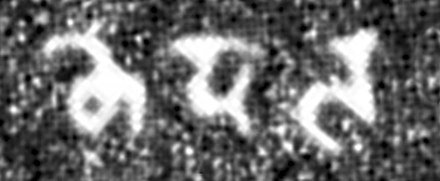
Nēpāla" in the late Brahmi script, in the Allahabad Pillar inscription of Samudragupta (350–375 CE).[15]
Before the unification of Nepal, the Kathmandu Valley was known as Nepal.[c] The precise origin of the term Nepāl is uncertain. Nepal appears in ancient Indian literary texts dated as far back as the fourth century BC.[which?] An absolute chronology can not be established, as even the oldest texts may contain anonymous contributions dating as late as the early modern period. Academic attempts to provide a plausible theory are hindered by the lack of a complete picture of history and insufficient understanding of linguistics or relevant Indo-European and Tibeto-Burman languages.[17]
According to Hindu mythology, Nepal derives its name from an ancient Hindu sage called Ne, referred to variously as Ne Muni or Nemi. According to Pashupati Purāna, as a place protected by Ne, the country in the heart of the Himalayas came to be known as Nepāl.[18][19][d] According to Nepāl Mahātmya,[e] Nemi was charged with protection of the country by Pashupati.[20] According to Buddhist mythology, Manjushri Bodhisattva drained a primordial lake of serpents to create the Nepal valley and proclaimed that Adi-Buddha Ne would take care of the community that would settle it. As the cherished of Ne, the valley would be called Nepāl.[21] According to Gopalarājvamshāvali, the genealogy of ancient Gopala dynasty compiled c. 1380s, Nepal is named after Nepa the cowherd, the founder of the Nepali scion of the Abhiras. In this account, the cow that issued milk to the spot, at which Nepa discovered the Jyotirlinga of Pashupatināth upon investigation, was also named Ne.[17]
Norwegian indologist Christian Lassen had proposed that Nepāla was a compound of Nipa (foot of a mountain) and -ala (short suffix for alaya meaning abode), and so Nepāla meant "abode at the foot of the mountain". He considered Ne Muni to be a fabrication.[22] Indologist Sylvain Levi found Lassen's theory untenable but had no theories of his own, only suggesting that either Newara is a vulgarism of sanskritic Nepala, or Nepala is Sanskritisation of the local ethnic;[23] his view has found some support though it does not answer the question of etymology.[24][25][26][17] It has also been proposed that Nepa is a Tibeto-Burman stem consisting of Ne (cattle) and Pa (keeper), reflecting the fact that early inhabitants of the valley were Gopalas (cowherds) and Mahispalas (buffalo-herds).[17] Suniti Kumar Chatterji believed Nepal originated from Tibeto-Burman roots – Ne, of uncertain meaning (as multiple possibilities exist), and pala or bal, whose meaning is lost entirely.[27]
History
Ancient Nepal
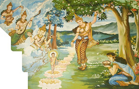
This painting in a Laotian temple depicts a legend surrounding the birth of Gautama Buddha c. 563 BC in Lumbini, Western Nepal.
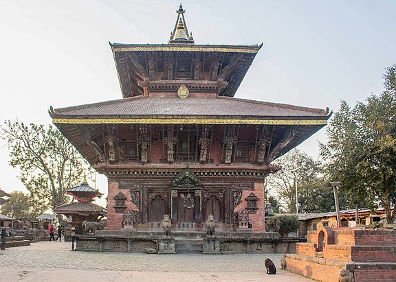
In the premises of the Changu Narayan Temple, is a stone inscription dated 464 AD, the first in Nepal since the Ashoka inscription of Lumbini (c. 250 BC).
By 55,000 years ago, the first modern humans had arrived on the Indian subcontinent from Africa, where they had earlier evolved.[28][29][30] The earliest known modern human remains in South Asia date to about 30,000 years ago.[31] The oldest discovered archaeological evidence of human settlements in Nepal dates to around the same time.[32]
After 6500 BC, evidence for the domestication of food crops and animals, construction of permanent structures, and storage of agricultural surplus appeared in Mehrgarh and other sites in what is now Balochistan.[33] These gradually developed into the Indus Valley civilisation,[34][33] the first urban culture in South Asia.[35] Prehistoric sites of palaeolithic, mesolithic and neolithic origins have been discovered in the Siwalik hills of Dang district.[36] The earliest inhabitants of modern Nepal and adjoining areas are believed to be people from the Indus Valley civilisation. It is possible that the Dravidian people whose history predates the onset of the Bronze Age in the Indian subcontinent (around 6300 BC) inhabited the area before the arrival of other ethnic groups like the Tibeto-Burmans and Indo-Aryans from across the border.[37] By 4000 BC, the Tibeto-Burmese people had reached Nepal either directly across the Himalayas from Tibet or via Myanmar and north-east India or both.[38] Stella Kramrisch (1964) mentions a substratum of a race of pre-Dravidians and Dravidians, who were in Nepal even before the Newars, who formed the majority of the ancient inhabitants of the valley of Kathmandu.[39]
By the late Vedic period, Nepal was being mentioned in various Hindu texts, such as the late Vedic Atharvaveda Pariśiṣṭa and in the post-Vedic Atharvashirsha Upanishad.[40] The Gopal Bansa was the oldest dynasty to be mentioned in various texts as the earliest rulers of the central Himalayan kingdom known by the name 'Nepal'.[41] The Gopalas were followed by Kiratas who ruled for over 16 centuries by some accounts.[42] According to the Mahabharata, the then Kirata king went to take part in the Battle of Kurukshetra. In the south-eastern region, Janakpurdham was the capital of the prosperous kingdom of Videha or Mithila, that extended down to the Ganges, and home to King Janaka and his daughter, Sita.
Around 600 BC, small kingdoms and confederations of clans arose in the southern regions of Nepal. From one of these, the Shakya polity, arose a prince who later renounced his status to lead an ascetic life, founded Buddhism, and came to be known as Gautama Buddha (traditionally dated 563–483 BC).[43] Nepal came to be established as a land of spirituality and refuge in the intervening centuries, played an important role in transmitting Buddhism to East Asia via Tibet,[44] and helped preserve Hindu and Buddhist manuscripts.
By 250 BC, the southern regions had come under the influence of the Maurya Empire. Emperor Ashoka made a pilgrimage to Lumbini and erected a pillar at Buddha's birthplace, the inscriptions on which mark the starting point for properly recorded history of Nepal.[45] Ashoka also visited the Kathmandu valley and built monuments commemorating Gautama Buddha's visit there. By the 4th century AD, much of Nepal was under the influence of the Gupta Empire.[f][46]
In the Kathmandu valley, the Kiratas were pushed eastward by the Licchavis, and the Licchavi dynasty came into power c. 400 AD. The Lichchhavis built monuments and left a series of inscriptions; Nepal's history of the period is pieced together almost entirely from them.[47][44] In 641, Songtsen Gampo of the Tibetan Empire sends Narendradeva back to Licchavi with an army and subjugates Nepal. Parts of Nepal and Licchavi was later under the direct influences of the Tibetan empire.[48] The Licchavi dynasty went into decline in the late 8th century and was followed by a Thakuri rule. Thakuri kings ruled over the country up to the middle of the 11th century AD; not much is known of this period that is often called the dark period.[49]
Medieval Nepal
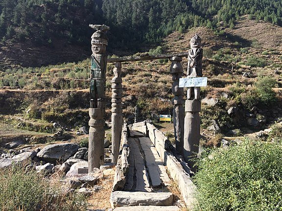
Sinja Valley, thought to be the place of origin of the Khasas and the Nepali language, was at the heart of the Khas Malla empire.
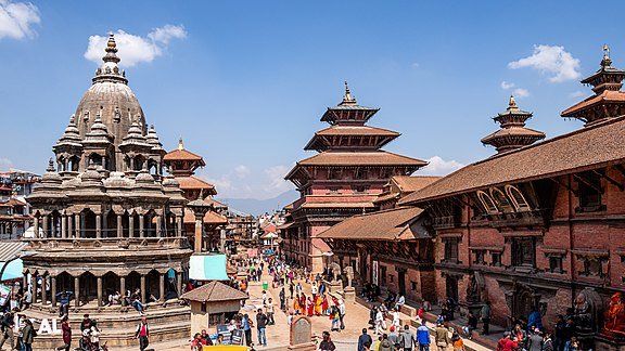
Patan Durbar Square, one of the three palace squares in the Kathmandu Valley, was built by the Mallas in the 17th century. The Durbar Squares are a culmination of over a millennium of development in Nepali art and architecture.
In the 11th century, a powerful empire of Khas people emerged in western Nepal whose territory at its highest peak included much of western Nepal as well as parts of western Tibet and Uttarakhand of India. By the 14th century, the empire had splintered into loosely associated Baise rajyas, literally 22 states as they were counted. The rich culture and language of the Khas people spread throughout Nepal and as far as Indo-China in the intervening centuries; their language, later renamed the Nepali language, became the lingua franca of Nepal as well as much of North-east India.[44]
In south-eastern Nepal, Simraungarh annexed Mithila around 1100 AD, and the unified Tirhut stood as a powerful kingdom for more than 200 years,[50] even ruling over Kathmandu for a time.[51] After another 300 years of Muslim rule, Tirhut came under the control of the Sens of Makawanpur.[50] In the eastern hills, a confederation of Kirat principalities ruled the area between Kathmandu and Bengal.
In the Kathmandu valley, the Mallas, who make several appearances in Nepalese history since ancient times, had established themselves in Kathmandu and Patan by the middle of the 14th century. The Mallas ruled the valley first under the suzerainty of Tirhut but established independent reign by late 14th century as Tirhut went into decline. In the late 14th century, Jayasthiti Malla introduced widespread socio-economic reforms, principal of which was the caste system. By dividing the indigenous non-Aryan Buddhist population into castes modelled after the four Varna system of Hinduism, he provided an influential model for the Sanskritisation and Hinduisation of the indigenous non-Hindu tribal populations in all principalities throughout Nepal. By the middle of the 15th century, Kathmandu had become a powerful empire which, according to Kirkpatrick, extended from Digarchi or Sigatse in Tibet to Tirhut and Gaya in India.[52] In the late 15th century, Malla princes divided their kingdom in four – Kathmandu, Patan and Bhaktapur in the valley and Banepa to the east. The competition for prestige among these brotherly kingdoms saw the flourishing of art and architecture in central Nepal, and the building of famous Kathmandu, Patan and Bhaktapur Durbar Squares; their division and mistrust led to their fall in the late 18th century, and ultimately, the unification of Nepal into a modern state.[44][53]
Apart from one destructive sacking of Kathmandu valley in the mid 14th century,[54] Nepal remains largely untouched by the Muslim invasion of India that began in the 11th century. The Mughal period saw an influx of high-caste Hindus from India into Nepal. They soon intermingled with the Khas people and by the 16th century, there were about 50 Rajput-ruled principalities in Nepal, including the 22 (Baisi) states and, to their east in west-central Nepal, 24 Chaubisi states. There emerged a view that Nepal remained the true bastion of unadulterated Hinduism at a time when Indian culture had been influenced by centuries of Mughal, followed by British rule. Gorkha, one of the Baisi states, emerged as an influential and ambitious kingdom with a reputation for justice, after it codified the first Hinduism-based laws in the Nepalese hills.[44]
Unification, expansion and consolidation (1768–1951)
.jpg)
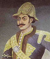
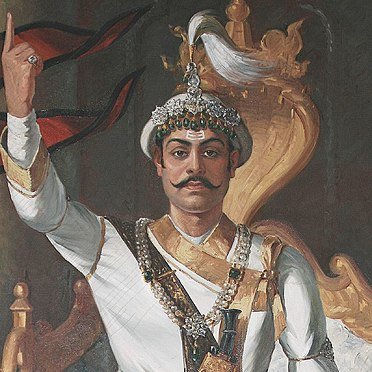
Prithvi Narayan Shah, began the unification process of what would become the present-day country of Nepal
During Bhimsen Thapa's premiership Nepal reached its zenith
.png)
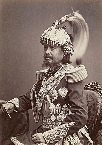
Jung Bahadur Rana, who established the autocratic Rana regime in 1846 and instituted a pro-British foreign policy
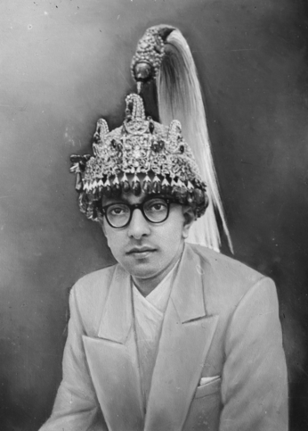
During King Mahendra's reign, Nepal experienced a period of industrial, political, and economic change.
In 1996, the Maoist Party started a violent bid to replace the royal parliamentary system with a people's republic.[62] This led to the long Nepali Civil War and more than 16,000 deaths.[64] With the death of both the King and the Crown Prince in a massacre in the royal palace, King Birendra's brother Gyanendra inherited the throne in 2001[62] and subsequently assumed full executive powers aiming to quash the Maoist insurgency himself.[65]
The Maoist Party joined mainstream politics following the success of the peaceful democratic revolution of 2006;[66] Nepal became a secular state,[67] and on 28 May 2008, it was declared a federal republic,[66] ending its time-honoured status as the world's only Hindu kingdom.[68] After a decade of instability and internal strife which saw two constituent assembly elections,[69][70][71][72] the new constitution was promulgated on 20 September 2015, making Nepal a federal democratic republic divided into seven provinces.[73][74]
Geography
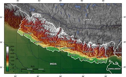
Nepal is of roughly trapezoidal shape, about 800 kilometres (500 mi) long and 200 kilometres (120 mi) wide, with an area of 147,516 km2 (56,956 sq mi). It lies between latitudes 26° and 31°N, and longitudes 80° and 89°E. Nepal's defining geological processes began 75 million years ago when the Indian plate, then part of the southern supercontinent Gondwana, began a north-eastward drift caused by seafloor spreading to its south-west, and later, south and south-east.[75] Simultaneously, the vast Tethyn oceanic crust, to its northeast, began to subduct under the Eurasian plate.[75] These dual processes, driven by convection in the Earth's mantle, both created the Indian Ocean and caused the Indian continental crust eventually to under-thrust Eurasia and to uplift the Himalayas.[75] The rising barriers blocked the paths of rivers creating large lakes, which only broke through as late as 100,000 years ago, creating fertile valleys in the middle hills like the Kathmandu Valley. In the western region, rivers which were too strong to be hampered, cut some of the world's deepest gorges.[76] Immediately south of the emerging Himalayas, plate movement created a vast trough that rapidly filled with river-borne sediment[77] and now constitutes the Indo-Gangetic Plain.[78] Nepal lies almost completely within this collision zone, occupying the central sector of the Himalayan arc, nearly one-third of the 2,400 km (1,500 mi)-long Himalayas,[79][80][81][82][83][84] with a small strip of southernmost Nepal stretching into the Indo-Gangetic plain and two districts in the northwest stretching up to the Tibetan plateau.[76]
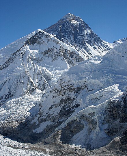
Mount Everest, the highest peak on earth, lies on the Nepal–China border.
Nepal is divided into three principal physiographic belts known as Himal–Pahad–Terai.[g] Himal is the mountain region containing snow and situated in the Great Himalayan Range; it makes up the northern part of Nepal. It contains the highest elevations in the world including 8,848.86 metres (29,032 ft) height Mount Everest (Sagarmāthā in Nepali) on the border with China. Seven other of the world's "eight-thousanders" are in Nepal or on its border with Tibet: Lhotse, Makalu, Cho Oyu, Kangchenjunga, Dhaulagiri, Annapurna and Manaslu. Pahad is the mountain region that does not generally contain snow. The mountains vary from 800 to 4,000 metres (2,600 to 13,100 ft) in altitude, with progression from subtropical climates below 1,200 metres (3,900 ft) to alpine climates above 3,600 metres (11,800 ft). The Lower Himalayan Range, reaching 1,500 to 3,000 metres (4,900 to 9,800 ft), is the southern limit of this region, with subtropical river valleys and "hills" alternating to the north of this range. Population density is high in valleys but notably less above 2,000 metres (6,600 ft) and very low above 2,500 metres (8,200 ft), where snow occasionally falls in winter. The southern lowland plains or Terai bordering India are part of the northern rim of the Indo-Gangetic Plain. Terai is the lowland region containing some hill ranges. The plains were formed and are fed by three major Himalayan rivers: the Koshi, the Narayani, and the Karnali as well as smaller rivers rising below the permanent snowline. This region has a subtropical to tropical climate. The outermost range of the foothills called Sivalik Hills or Churia Range, cresting at 700 to 1,000 metres (2,300 to 3,280 ft), marks the limits of the Gangetic Plain. Broad, low valleys called Inner Terai Valleys (Bhitri Tarai Upatyaka) lie north of these foothills in several places
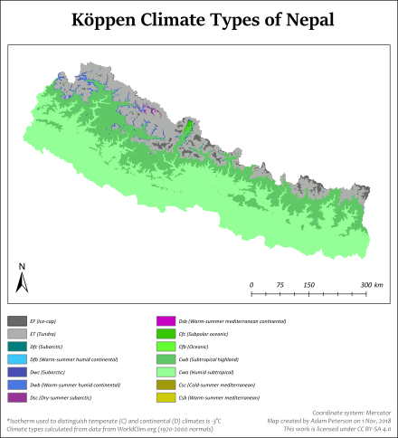
Köppen climate classification for Nepal
The Indian plate continues to move north relative to Asia at about 50 mm (2.0 in) per year.[85] This makes Nepal an earthquake-prone zone, and periodic earthquakes that have devastating consequences present a significant hurdle to development.[86] Erosion of the Himalayas is a very important source of sediment, which flows to the Indian Ocean.[87] Saptakoshi, in particular, carries a huge amount of silt out of Nepal but sees extreme drop in Gradient in Bihar, causing severe floods and course changes, and is, therefore, known as the sorrow of Bihar. Severe flooding and landslides cause deaths and disease, destroy farmlands and cripple the transport infrastructure of the country, during the monsoon season each year.
Nepal has five climatic zones, broadly corresponding to the altitudes. The tropical and subtropical zones lie below 1,200 metres (3,900 ft), the temperate zone 1,200 to 2,400 metres (3,900 to 7,900 ft), the cold zone 2,400 to 3,600 metres (7,900 to 11,800 ft), the subarctic zone 3,600 to 4,400 metres (11,800 to 14,400 ft), and the Arctic zone above 4,400 metres (14,400 ft). Nepal experiences five seasons: summer, monsoon, autumn, winter and spring. The Himalayas block cold winds from Central Asia in the winter and form the northern limits of the monsoon wind patterns.
Biodiversity
Land_cover_map_of_Nepal_using_Landsat_30_m_(2010)_data (1).jpg
This land cover map of Nepal using Landsat 30 m (2010) data shows forest cover as the dominant type of land cover in Nepal.[88]
The greater one-horned rhinoceros roams the sub-tropical grasslands of the Terai plains.
Nepal contains a disproportionately large diversity of plants and animals, relative to its size.[89][90] Nepal, in its entirety, forms the western portion of the eastern Himalayan biodiversity hotspot, with notable biocultural diversity.[91] The dramatic differences in elevation found in Nepal (60 m from sea level in the Terai plains, to 8,848 m Mount Everest)[92] result in a variety of biomes.[89] The Eastern half of Nepal is richer in biodiversity as it receives more rain, compared to western parts, where arctic desert-type conditions are more common at higher elevations.[90] Nepal is a habitat for 4.0% of all mammal species, 8.9% of bird species, 1.0% of reptile species, 2.5% of amphibian species, 1.9% of fish species, 3.7% of butterfly species, 0.5% of moth species and 0.4% of spider species.[90] In its 35 forest-types and 118 ecosystems,[89][h] Nepal harbours 2% of the flowering plant species, 3% of pteridophytes and 6% of bryophytes.[90]
The greater one-horned rhinoceros roams the sub-tropical grasslands of the Terai plains.
Nepal's forest cover is 59,624 km2 (23,021 sq mi), 40.36% of the country's total land area, with an additional 4.38% of scrubland, for a total forested area of 44.74%, an increase of 5% since the turn of the millennium.[93] The country had a 2019 Forest Landscape Integrity Index mean score of 7.23/10, ranking it 45th globally out of 172 countries.[94] In the southern plains, Terai–Duar savanna and grasslands ecoregion contains some of the world's tallest grasses as well as Sal forests, tropical evergreen forests and tropical riverine deciduous forests.[95] In the lower hills (700 m – 2,000 m), subtropical and temperate deciduous mixed forests containing mostly Sal (in the lower altitudes), Chilaune and Katus, as well as subtropical pine forest dominated by chir pine are common. The middle hills (2,000 m – 3,000 m) are dominated by oak and rhododendron. Subalpine coniferous forests cover the 3,000 m to 3,500 m range, dominated by oak (particularly in the west), Eastern Himalayan fir, Himalayan pine and Himalayan hemlock; rhododendron is common as well. Above 3,500 m in the west and 4,000 m in the east, coniferous trees give way to rhododendron-dominated alpine shrubs and meadows.[90]
Among the notable trees, are the astringent Azadirachta indica, or neem, which is widely used in traditional herbal medicine,[96] and the luxuriant Ficus religiosa, or peepal,[97] which is displayed on the ancient seals of Mohenjo-daro,[98] and under which Gautam Buddha is recorded in the Pali canon to have sought enlightenment.[99]