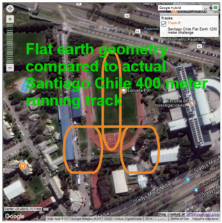
These are actual traces of what properly proportioned 400 m tracks laid out in Santiago Chile according to flat earth circular disk geometry would look like compared to an actual existing properly proportioned track there at Escuela PDI.
Three flat earth geometry tracings of properly proportioned 400 meter tracks overlaying actual 400 meter track in Santiago Chile, one tracing with long dimension running north south and two with long dimension running east west. The flat earth trace with the long dimension running north south exhibits the proportion similar to that of a cigar, whereas the two flat earth traces with long dimensions running east west exhibit the proportions of a pill box.
The Excel file with these traces is documented here.
ChileLeftRightShaftV2Vis Excel file
https://www.scribd.com/document/366968591/Chile-Left-Right-Shaft-v-2-Vis
This graphically illustrates the gross distortions in dimensions that occur in the southern lands when comparing imaginary flat earth geometry to real spherical earth geometry.