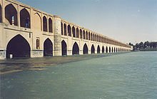
The Zayandeh starts in the Zagros Mountains and flows 400 kilometres (200 mi) eastward before ending in the Gavkhouni swamp, a seasonal salt lake, southeast of Esfahan city. The Zayandeh has significant flow all year long, unlike many of Iran's rivers which are seasonal. The Zayandeh is spanned by many historical Safavid era bridges, and flows through many parks.
The Zayandeh River basin has an area of 41,500 square kilometres (16,000 sq mi), altitude from 3,974 metres (13,038 ft) to 1,466 metres (4,810 ft), an average rain fall of 130 millimetres (5 in) and a monthly average temperature of 3 °C (37 °F) to 29 °C (84 °F). There are 2,700 square kilometres (1,000 sq mi) of irrigated land in the Zayandeh River basin, with water derived from the nine main hydraulic units of the Zayandeh River, wells, qanat and springs in lateral valleys. Zayandeh River water gives life to the people of central Iran mainly in Isfahan and Yazd provinces. Water diverted per person is 240 litres (63 US gallons/53 imp gallons) per day in urban and 150 litres (40 US gallons/33 imp gallons) per day in villages.[1] The flow of the river has been estimated at 1.2 cubic kilometres (0.30 cu mi) per annum, or 38 cubic metres (1,340 cu ft) per second.

Hi! I am a robot. I just upvoted you! I found similar content that readers might be interested in:
https://en.wikipedia.org/wiki/Zayanderud
Downvoting a post can decrease pending rewards and make it less visible. Common reasons:
Submit