INTRODUCTION
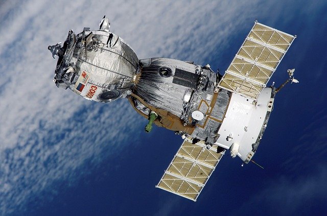
 Satellite in space
(License: Public Domain]: Pixabay
 Remote sensing as a field of study is one that is not yet quite an household thing. If not in the advanced nations, it is at least in the developing nations of the world. When the word remote sensing comes to a person for the first time, the basic picture that comes to mind is of one with a remote control shuffling through the channels on his Television set. While this is actually true, the science of remote sensing is not only limited to the use of your TV remote control to switch between a soccer match and trending news channels.
I will therefore in this write up and subsequent ones, give an insight into the concept of remote sensing, the electromagnetic spectrum, RADAR which is one of the popular and useful satellites in remote sensing. In our remote sensing series today, we shall be starting with the definition and history of remote sensing and the seven(7) processes involved in this interesting concept.
The ball has been set rolling... Hop on and I hope you enjoy the ride!!!
So what is Remote Sensing?
Remote sensing involves the science and art of getting information (both Spatial and non Spatial) about an object, phenomenon or feature on the earth surface with or without necessarily getting in touch with it.
Remember the remote control that was made mention of earlier right? Yea, that can give you a basic understanding into what remote sensing does. Just the way your remote control gives instructions to your gadgets from a distance without having necessary contact with them, that is the same way remote sensors get information about things from distances.
One of the best definitions you would find around is this one by the USGS which defines remote sensing as;
the process of detecting and monitoring the physical characteristics of an area by measuring its reflected and emitted radiation at a distance from the targeted area.
It can be used in the mapping of large forest fire, prediction of weather by tracking cloud movements, monitoring natural hazards such as volcano and hurricane development, tracking urbanization of an area and so much more.
Now that we have a fundamental understanding of the science and art of remote sensing, let us consider how it all started.
BRIEF HISTORY OF REMOTE SENSING
According to the great Greek philosopher, Socrates;
man can only understand the world he lives in if he succeeds in rising above the earth, to the top of the atmosphere and even beyond. Only then will he be able to comprehend this world he lives in.
The desire of man to not only know what happens on the earth but also high above even to outer space gave birth to aerial photography. Remote sensing therefore began from photography.
During the first world War, aerial photography was a very important tool and as at during the world War II it had become a very valuable tool used for reconnaissance. Instead of sending soldiers to spy on the enemy, aerial photos where taking. With this decisions can be made and the enemy territory can be understood to a certain level of accuracy by the warring soldiers.
Aerial photography and by extension remote sensing therefore started in the 1840s as balloonists used the then newly invented photo-camera to capture pictures of the ground from the balloon high above.
In 1957 the launching of the sputnik(an artificial satellite) by the Soviet Union opens the world to the possibilities of space borne satellite imagery. Since then many remote sensing satellites have being launched by different countries in their effort to explore the outer space.
Foremost of this is the LANDSAT the first satellite dedicated to monitoring land and ocean surfaces launched by the United states with the purpose of mapping natural and cultural resources.
It currently has 8 missions (i.e 8 LANDSAT have being launched) with Landsat 1 launched on 23rd, July 1972.
So many satellites now have being launched into space such as the NIGSAT 1, NIGSAT X, MODIS, SPOT etc.source
Processes of Remote Sensing
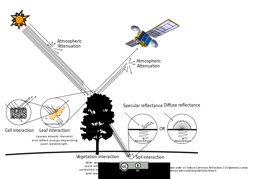
 Remote sensing Energy Interactions
(License: CC-BY-3.0]: Wikicommons
 As mentioned earlier, there are seven (7) processes of remote sensing which are considered below;
Source of light or Energy:
For remote sensing to take place, the basic and fundamental requirement is the energy source. This source provides the energy in the form of electromagnetic energy. This source can either be NATURAL or ARTIFICIAL.
Natural source(s) includes the SUN while the artificial sources include any other source of light apart from the SUN.
Relation with the atmosphere:
When the energy is released from the source, it travels through space (the atmosphere) and by so doing interactions take place. These interactions may include: REFLECTION, SCATTERING OR ABSORPTION.
Reflection is just the redirection of electromagnetic radiation from its original direction. As the energy travels part if it gets redirected back to the atmosphere while some are absorbed by particles in the atmosphere such as aerosols, Ozone etc and some are eventually scattered.
The remaining part of the radiation that gets to the target is what in remote sensing called “THE ATMOSPHERIC WINDOW” and this is the part that is useful to remote sensing.
Relation with the target:
The atmospheric window interacts also with the target. Depending on the nature of the target, the energy either gets REFLECTED or ABSORBED. What determines how much a target reflects a radiation is its ALBEDO. Albedo is the measure of how well an object can reflect an incident radiation in its surface. Smoother or brighter surfaces reflects higher than rough surfaces ( rough surfaces do more of scattering than reflecting). The reflection from the target is what is recorded by a device called SENSOR and that is the information we talk about in remote sensing.
Recording of the reflected energy by the Sensor:
A sensor like I said is a device that detects electromagnetic radiation. It can either be PASSIVE or ACTIVE.
Active sensors are those sensors that generate or produce their own source of energy, they use the artificial source such as the RADAR that sends out a microwave radiation towards a target and then uses the returned energy to record information about that target while the passive sensors uses the natural source of energy such as the sun.
The basic advantage of the active sensor over passive is that the latter can get information about a target at anytime of the day even in the night while passive is only during the daytime.
This device records the energy reflected back by the target. Sensors are always calibrated on board Satellites.
Transmission, Reception and Processing:
When the sensor is done recording the energy, there is need for it to be transmitted to a ground receiving station. It is transfer in an electronic format. This energy received at the station is then processed by experts.
Some of the operations include:
Compression: there's a need for the received data to be compressed into a smaller size because it's always very heavy. This will enable the end users of the data to be able to download it easier and much faster.
Image enhancement: theirs is the need to enhance the image to make it look more appealing to the users. This is because satellite images always contain so much noise (unwanted information) such as clouds etc and this needs to be removed from the image to make it look better to the eyes.
Other processing operations include Radiometric corrections.
Interpreting and Analyzing:
After processing these images, there is need for interpreting them as to whatever application of use. Interpreting the images will also entail that the images be analyzed to understand every feature. This will enhance understanding and comprehension of the generated image.
Application of derived information:
Of what use is information if doesn't help to solve a problem? Same way the information gotten from these images needs to be applied to solve a problem or help better understand a feature or phenomenon. There are many applications of remote sensing information. Some of them are in: hydrology, Agriculture, Military, Urbanization, Geology, Morphology etc.
These seven items listed above encompasses the whole of the remote sensing process from beginning to the end. Fundamental of remote sensing
Having gotten basic knowledge about the remote sensing process, there’s a need to further discuss on the electromagnetic spectrum so as to understand it better and see the extent of its potentials in remote sensing applications.
We shall be discussing on the electromagnetic spectrum in my next post.
Nice post bro looking forward to your next post
Downvoting a post can decrease pending rewards and make it less visible. Common reasons:
Submit