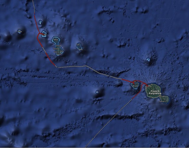
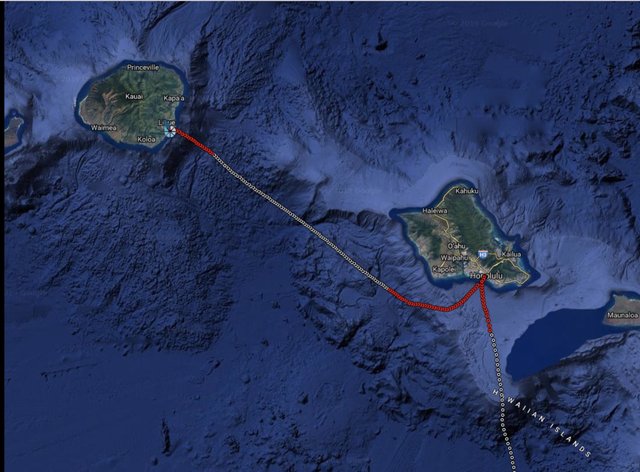
There's files that have jurisdictional boundaries defined by GPS coordinates. We just check what boundary area the GPS coordinate falls in. It works anywhere in the world.
Check out recent plots of Lana's trip. Red sections are when the ship wasn't in international waters, So we now have automated checking that controls when transactions are signed.


So far, we've just been initiating transactions from an automated wallet. Now Dan is working on getting blocks signed when the dots are not red.
This is a revolutionary breakthrough.
The idea of jurisdictional agility is going to interest the institutions who are presently on the sidelines. The big money is itching to get in but they have the SEC to content with. Now, by choosing where the transactions occur, they can remain in compliance.
This is a radical idea and a stage we need to go through.
Downvoting a post can decrease pending rewards and make it less visible. Common reasons:
Submit
How cool is Dan Notestein!? I was wondering if we were in international waters or not between the Hawaiian islands. BEOS continues to be the historical leader in earth shattering innovations that set BEOS hugely apart from the rest of the crypto world!! International waters, jurisdiction NONE ! Love your post and leadership Stan!!
Downvoting a post can decrease pending rewards and make it less visible. Common reasons:
Submit
Very cool
Downvoting a post can decrease pending rewards and make it less visible. Common reasons:
Submit
Nice...
And I would add that another way would be to offer the "jurisdictional claimant" the opportunity to offer satisfactory evidence to proove their claim.
Downvoting a post can decrease pending rewards and make it less visible. Common reasons:
Submit
Thanks, @stan, for sharing these plots....
Fascinating to "connect the dots" and see where the BEOS blocks have been signed in a geographic context.
How are the "international waters" locales defined for the purpose of these plots, i.e., red v grey dots? Is it purely a "distance from land/territory" algorithm, or is there some kind of GPS lookup?
Totally cool...
😄😇😄

Downvoting a post can decrease pending rewards and make it less visible. Common reasons:
Submit
GPS lookup of boundaries defining territorial claims.
Downvoting a post can decrease pending rewards and make it less visible. Common reasons:
Submit
Thanks! :)
Downvoting a post can decrease pending rewards and make it less visible. Common reasons:
Submit
The only way how DanNote can do such thing is to write a software that will analyze GPS location constantly and instruct block producer based on GPS location or to provide valid key or to provide key for "disabled" such all Graphene chains have (option to prevent block producer missing blocks).
Correct or I'm off here ?
It's quite complicated to bridge Linux, Blockchain, and write another piece of software that will use Geo analysis based on GPS location (International waters or not) and hats down to Notestein for efforts!
Chee®s
Downvoting a post can decrease pending rewards and make it less visible. Common reasons:
Submit
I pray that your trip will be more enjoyable and all transactions will go smoothly
Downvoting a post can decrease pending rewards and make it less visible. Common reasons:
Submit