Complex Storm System Means Uncertainty Very High

Complex Storm System Means Uncertainty Very High
We all know by now that the level of uncertainty with storm systems is always high 5 days out and in this case the level of uncertainty is probably twice what it normally is. Looking at all the models this afternoon illustrates this. They are all different and the forecast from each one would make you think you were living in three different worlds.
EUROPEAN UPPER AIR TUESDAY MARCH 20TH 2018

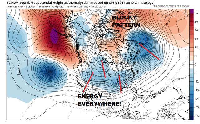
A couple of things the models have in common is that they all hold on to the blocky signature across the North Atlantic next week. They all show energy everywhere. I chose the European model for Tuesday morning to illustrate this. It's hard enough when there is only 1 in play. Here we have four systems in play. The one in the North Atlantic is part of the block and that pretty much ensures that the energy to the west finds its way to the Middle Atlantic Coast. The problem with this is we have each model showing different strengths and different outcomes.
GFS FORECAST WEDNESDAY MARCH 21, 2018

Here is one possible outcome with the GFS which would have mostly snow from Central New Jersey northward from late Tuesday into Wednesday morning. The European for Wednesday morning is further south which brings snow to areas in Maryland, Northern Virginia & Southern Pennsylvania but no further north than Central New Jersey.
EUROPEAN MODEL WEDNESDAY MARCH 2, 2018

Then there is the issue of the second energy which is the low in Southern Ohio Wednesday morning which develops into another system Wednesday night and Thursday. The GFS is northwest of the European though the European brings snow as far north as Long Island and Northern New Jersey
EUROPEAN MODEL THURSDAY MARCH 22, 2018

The GFS on the other hand is northwest of the European and 12 hours faster. I could get into the Canadian which has a third alternative but what is the point. The idea that the model handling of this system or systems is poor is clear. The European yesterday had a low near Detroit and overnight was in between. The bottom line is that this next round of snow, rain, wind, and tides will be different from the first 3. Getting back to back systems is rare however since we just had 3 nor'easters in 10 days, I would not rule out anything at this point.
SHOP THE JOESTRADAMUS STORE
<iframe style="border: none; overflow: hidden;" src="https://www.facebook.com/plugins/post.php?href=https%3A%2F%2Fwww.facebook.com%2Fmeteorologistjoecioffi%2Fposts%2F10159926287540387&width=500" width="500" height="482" frameborder="0" scrolling="no"></iframe>
MANY THANKS TO TROPICAL TIDBITS FOR THE WONDERFUL USE OF THE MAPS

GET JOE A CIGAR IF YOU LIKE!
FiOS1 News Weather Forecast For Long Island
FiOS1 News Weather Forecast For New Jersey
FiOS1 News Weather Forecast For Hudson Valley
NATIONAL WEATHER SERVICE SNOW FORECASTS
LATEST JOESTRADAMUS ON THE LONG RANGE
<iframe style="border: none;" src="//rcm-na.amazon-adsystem.com/e/cm?o=1&p=12&l=ur1&category=gold&banner=1XD8WGXBAZC9QME1TFG2&f=ifr&lc=pf4&linkID=89e731526985455dfa8b4e7a2a920caa&t=meteorologisj-20&tracking_id=meteorologisj-20" width="300" height="250" frameborder="0" marginwidth="0" scrolling="no"></iframe>
Posted from my blog with SteemPress : http://www.meteorologistjoecioffi.com/index.php/2018/03/15/complex-storm-system-means-uncertainty-very-high/