Following up on my post from a few days ago.
TRUST KANSAS.
This was a clue from Q, if you didn't know.
"I've been reaching out and trying on the possibilities to try to locate the boundaries of my new Sanctuary. My bubble of time/space. I've been wrestling this issue since the shifts occurred, going back and forth on just WHERE the edges of it are. I reached out the day before yesterday again, and I did see something new. Somehow the 'paw' of Florida survived! A main part of the panhandle is still afloat, the tip and a good part of the leg. It is an island now and I think there are other small islands around it - these shifts have created a reality that is incredibly beautiful - it takes my breath away to see it. And this was a major move for me toward seeing more of the whole picture, or more of it revealing itself to me. But mostly I've been trying to figure out the boundaries for my region of Denver, Colorado Springs and Fort Collins, Colorado - beyond or surrounding us. What I consider the main landmass for the 'Untied States,' starting with this eastern ocean region... where is this mysterious Denver Coastline?"
Well, I've got more of it now.

THIS, is roughly the shape of 'our island' or our bubble of reality, surrounding its manifestor. If you have read me before, you know my philosophy of the 144 Thousand, who are magical people that manifest 'Domes' of safety and sanctuary around them, as reflections of genetic code and connection to the Earth Grid. I've started writing about them just a bit lately as "Parentals." It was my friend Charles that suggested the idea. He would like to someday have an addition to the Right Use of Will books as a collection of writings among some of us who know and understand the material, published with a black cover and matching the rest of the series of books. Call it a new chapter.
So what is the connection to Antarctica?
I think that Antarctica is a magical place of First Manifestation. Original Cause on Earth or the "Earth Blueprint," perhaps. When Irma shifted, I was sent a (I think leaked) NASA photograph showing what had become of my location and the first thing I noticed was its likeness to the island shape of Antarctica. Only I'm near Denver. Also, I had a very powerful sense of being in the location of Alaska, USA. In terms of being way north and just left of the North Pole, looking at the planet with the United States and South America on its face.
I feel that there have been shifts not only with the Earth landscape but also the astronomy. For one thing, I remember last fall, watching the skies and the Moon was doing something really strange. It was showing up in different places in the sky on consecutive nights, that didn't make any sense.
So the first thing I was aware of was a new coastline out east of my position, from late August/early September 2017. I remember the first time I descended from the mountains into the Denver suburbs after the start of this shift, about six weeks later. You can't see the horizon from where I live because of the mountains. I had seen a DOT (Colorado Department of Transportation) video that showed only a couple of frames but you could clearly see this ocean, east of Interstate 70. I showed this to a few people who also saw it, but then it was later edited out. And replayed over and over again. As if to try to bully me out of what I and possibly other people had seen. There is some kind of mass illusion surrounding it now.
I've been puzzling over our boundaries since this time. Where are the edges of it?
I think I found an eastern edge. One, remembering the DOT video... the ocean was east of the City of Denver, not right up into it as one of the photographs that was sent to me implied, to throw me off I think. Also one of my Facebook friends sent me a comment about the airplane runway being very short and stressful. Someone who I believe knows the big picture and came here after the shift happened. So I think the new coast boundary may even cut into runway territory that was part of DIA (Denver International Airport). DIA is located on the Colorado plains east of Denver.
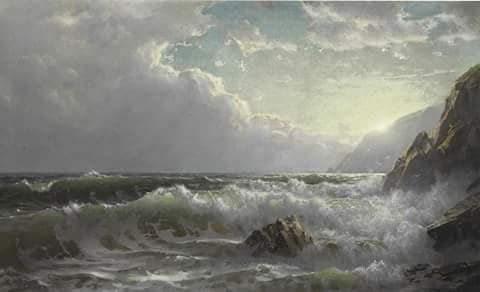
I saw this image today and it strikes a haunting chord in me.
It could be a similar view to looking southward down the new (east of) Denver Coastline on a stormy day.

Artist: William Trost Richards, 1833 - 1905
As I was looking for this photograph I noticed that I actually have quite a few photos in my cache to share. Proof kindof, or fuel for speculation at least.

Here's the NASA photograph that crossed my path. That "cloud" is another fascinating subject, adding description to this magical place. I think of it as Living (animal?) Spirit. The life of this place. 
Here's an image of Antarctica:

I think that the NASA photo curved edge of land is turned upside down, but that it matches the large curve on the right of Antarctica. Just in terms of orientation. Here's my image of the ending shape of the island, pretty close match other than that squiggle and peninsula to the left of Antarctica. Just one of those magical clues that find its way to me so often. Here it is again for comparison.

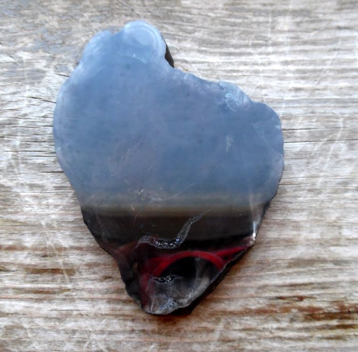
Also I feel that it is no accident that the stone in my photograph describing our island resembles so accurately, a real human heart. Both in perfect shape and actual size.
Reaching out, looking around. I got a few more boundary edges. I think the southernmost tip of the island rounds off central Arizona, and that Taos, New Mexico is someplace on the lower western edge of it. North of me has been almost a total blind spot until yesterday. I feel there is a sharp, cliffy drop to the northeast and then deep water. I had seen that the very north tip of the rock (it is a piece of black petrified wood) is where the landmass barely crosses into what used to be the State of Wyoming and when I pulled out the rock to photograph it for this article, it was a good match to the perspective of my visions of it all.
What I really need to do is sit down with a map and a cutout of this shape kindof to an estimated scale, and see just where these points would fall. From here there is no Texas and no Mexico. One of the most intense aspects of the shift was, Hurricane Irma as a huge force surging into the Gulf of Mexico from the east and literally breaking Mexico off of the main landmass, taking other things around it. I know that sounds violent and I am certain it was! But the days after these shifts I was seeing maps in my head, all over the place... of coastal areas that were populated and accounted for (strange movement in time here, as in a safe future reality). I think there are other sanctuaries and domes, or islands around that focus on other people within the 144 Thousand. This one is the largest one though, I think. And somehow the center one. It holds all the other ones in connection through an energy grid.
As I explained the other day, "There is also a dimensional overlap. That is, the space from 'Old Earth' and New Earth are overlapping somehow. So that the old picture of place and reality (with help from the fake media) is what is registering in the main consciousness as what is real and true for most people. As an Aquarian Moon person, I may have one foot in both worlds?"
This is so far my closest description of the main island of the Untied States, as mentioned by Q and Jordan Sather many months ago. Note that I didn't say 'United States.' I've been also trying to figure out the state of the State, or the Rule of Law here. As in, who has power over it all and what laws apply. We are after all, pretty much on another planet, with Old Earth behind us somehow.
In Conversation on Antarctic sovereignty: full discussion
http://theconversation.com/in-conversation-on-antarctic-sovereignty-full-discussion-28600
From that article:
"The 14th Venice Biennale of Architecture contains a surprise: the first-ever post-national Antarctopia pavilion. It aims to stimulate awareness of the continent’s global significance, to raise questions about the limits of sovereignty, even to get people thinking about Antarctica as an imagined utopia, a pointer to how people might think and live differently in the future, beyond sovereignty."
And
Who Owns Antarctica?
http://www.antarctica.gov.au/about-antarctica/people-in-antarctica/who-owns-antarctica
However, I feel that these claims only apply to Antarctica as located on Old Earth, it is not the same place here and now. I mean, for one thing it manifested here in this location with the dimensional overlap of my location in the United States. For another thing, I don't believe we are on Earth any longer. I've been referring to this place in my mind as New Earth.
(edit: I was afraid of this... parts of it are still confused. Looking at a map just now of the United States, I realize that New Mexico and Arizona are confused in my mind, almost reversed. Hm. Well, I will work on sorting this out, but what does it mean??? Could it be that the overlap somehow isn't exact? Or even an old timeline bleeding through?)
Q post from March 28:
"MSM talking about red v. blue pill?
Matrix reference?
Coincidence?"
Q
LOL, indeed.
April 1, 2018
(No, this post is not an April Fool's joke).
My first article to venture this specifically into this subject, from a few days ago -
TRUST KANSAS Steemit Post 3/28/2018
https://steemit.com/tarot/@mymoontao/trust-kansas
Edit/addition 4/8/2018
Q post, April 7.
"the island"
Wow... You sure put a lot of work and effort into this post... You may find the Truth you seek in my posts, so feel free to explore...
Downvoting a post can decrease pending rewards and make it less visible. Common reasons:
Submit
That cloud is sweet.
I think the elements own Antarctica. There are people there, but the weather is the real ruler of that place.
You are on a fascinating journey...
Downvoting a post can decrease pending rewards and make it less visible. Common reasons:
Submit