Gulf Of Alaska High Just Won't Go Away Long Range
Gulf Of Alaska High Just Won't Go Away Long Range
We continue to monitor with a certain degree of frustration the evolution of the long range weather pattern as we march through February. Days tick away for snow lovers who have either thrown in the towel on the rest of the winter and are lining up along mountainsides about to take the jump off the cliff. After a brutally cold and active start it has been nothing but cold air masses coming in and moving out and storm tracks to the west thanks to no blocking whatsoever. That pattern remains very progressive (fast west to east) with no signs of that changing anytime soon. For Central and Northern New England the snows continue and have been substantial. For the coast it has been either cheap thrills for some areas and not much at all elsewhere.
EUROPEAN JET STREAM FORECAST MONDAY FEB 12 2018
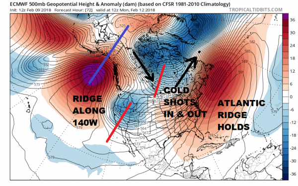
The European model for Monday morning illustrates the issue. The ridge along 140 degrees west is TOO FAR WEST. This creates troughing in the west. Though the flow is split with a vortex in Central Canada supplying cold air, the Atlantic ridge is strong and this creates a scenario where cold highs come down and move in and out. There is nothing to hold the cold air in. There is absolutely no blocking at all in the Atlantic. Looking ahead all the way out to day 10 there is no change in this regime.
EUROPEAN JET STREAM MONDAY FEBRUARY 19TH
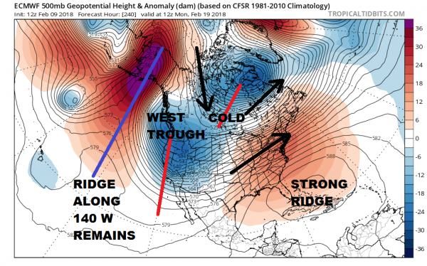
The only way we can see snow out of this is if somehow energy comes out in that southwest flow and times out with one of the cold shots coming down out of Canada. Models have been hinting at a possibility of this next weekend however everything would have to line up perfectly for even a minor snow event so we aren't exactly worked up over this. Looking out further ahead to Day 16 on the GFS, it looks like more of the same.
GFS JET STREAM SUNDAY FEBRUARY 25
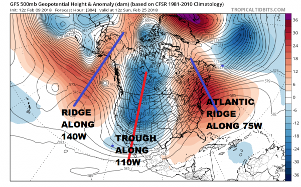
Until we see something that looks like a wholesale breakdown of this pattern, we will continue to see un-sustained cold shots lasting a day or 2, followed by warmer air and rain. Snow that matters will only occur if (and its a big if) the cold somehow were to time out perfectly with energy in the west southwest flow. The much talked about split of the vortex in the stratosphere remains the one unknown wild card in all this. Will this split drive a wholesale pattern change? That remains to be seen.
In opera it ain't over until the fat lady sings as the saying goes. Well she is clearing her throat and is about to walk on stage waiting for her cue.
<iframe style="border: none; overflow: hidden;" src="https://www.facebook.com/plugins/post.php?href=https%3A%2F%2Fwww.facebook.com%2Fmeteorologistjoecioffi%2Fposts%2F10159926287540387&width=500" width="500" height="482" frameborder="0" scrolling="no"></iframe>
MANY THANKS TO TROPICAL TIDBITS FOR THE WONDERFUL USE OF THE MAPS

GET JOE A CIGAR IF YOU LIKE!
FiOS1 News Weather Forecast For Long Island
FiOS1 News Weather Forecast For New Jersey
FiOS1 News Weather Forecast For Hudson Valley
NATIONAL WEATHER SERVICE SNOW FORECASTS
LATEST JOESTRADAMUS ON THE LONG RANGE
Weather App
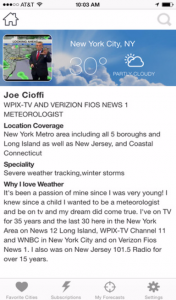
Don’t be without Meteorologist Joe Cioffi’s weather app. It is really a meteorologist app because you get my forecasts and my analysis and not some automated computer generated forecast based on the GFS model. This is why your app forecast changes every 6 hours. It is model driven with no human input at all. It gives you an icon, a temperature and no insight whatsoever.
It is a complete weather app to suit your forecast needs. All the weather information you need is right on your phone. Android or I-phone, use it to keep track of all the latest weather information and forecasts. This weather app is also free of advertising so you don’t have to worry about security issues with your device. An accurate forecast and no worries that your device is being compromised.
Use it in conjunction with my website and my facebook and twitter and you have complete weather coverage of all the latest weather and the long range outlook. The website has been redone and upgraded. Its easy to use and everything is archived so you can see how well Joe does or doesn’t do when it comes to forecasts and outlooks.
Just click on the google play button or the apple store button on the sidebar for my app which is on My Weather Concierge. Download the app for free. Subscribe to my forecasts on an ad free environment for just 99 cents a month.
Get my forecasts in the palm of your hand for less than the cost of a cup of Joe!
Original post : http://www.meteorologistjoecioffi.com/index.php/2018/02/09/gulf-alaska-high-just-wont-go-away-long-range/
