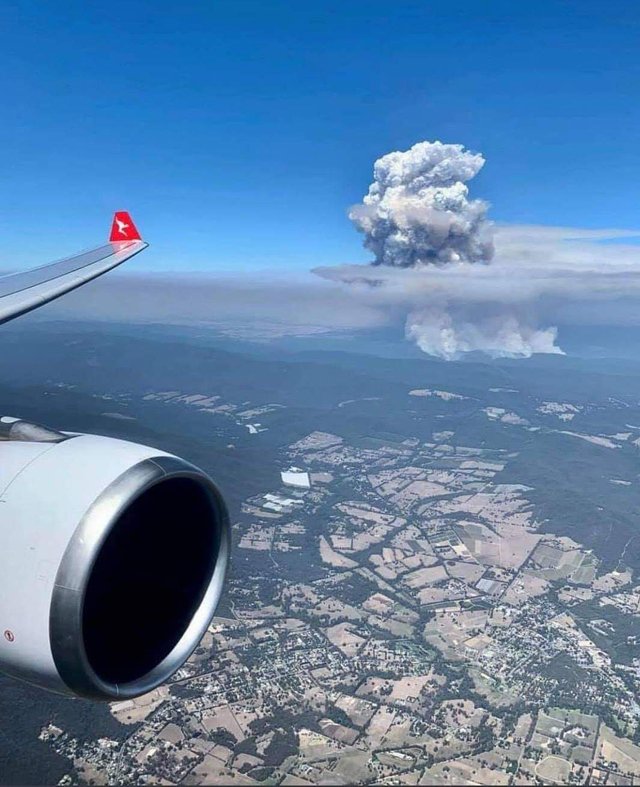
The Bunyip State Park fire in the Gippsland region of Victoria, Australia created a large pyrocumulonimbus cloud that reached up to 10 km high on Saturday, while on Sunday, the Licola fire, also in the Gippsland region, generated an explosive pyrocumulonimbus cloud reaching 12 km into the atmosphere and generated more than 1200 lightning strikes which subsequently ignited several small fires.
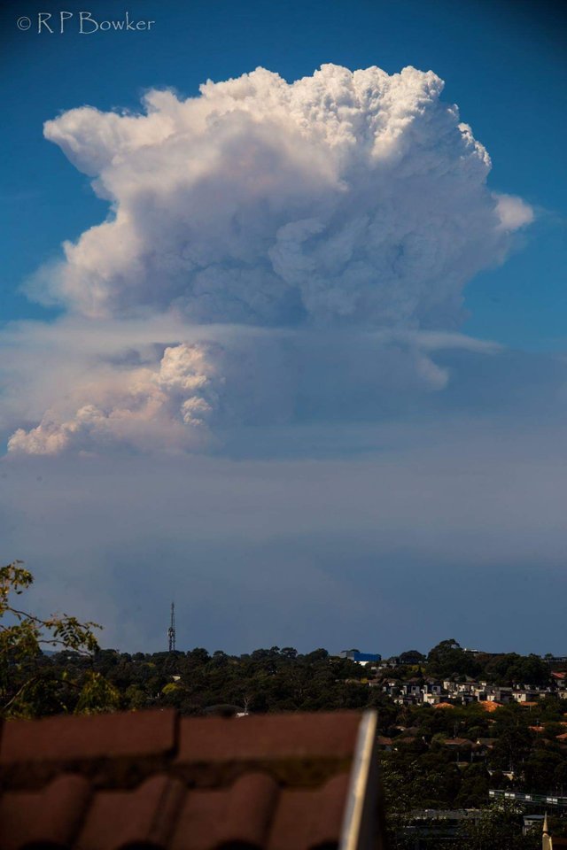
📸 Taylah Rosin
It’s well known that weather conditions can increase the risk of bushfires and make them harder to fight. But the relationship between fire and weather goes further—bushfires can create their own weather, generating ‘pyrocumulonimbus’ clouds and storms. So how do these form, why are they so dangerous and how are our scientists working to be able to predict them?
What are pyrocumulonimbus clouds?
They’re a thunderstorm that forms in the smoke plume of a fire (or nuclear bomb blast, or volcanic ash cloud). In Australia they most commonly form in large and intense bushfire smoke plumes. (The official name for clouds that form this way is 'flammagenitus', but they're commonly known as pyrocumulonimbus).
How do they form?
The intense heat from the fire causes air to rise rapidly in the smoke plume. The rising hot air is turbulent and draws in cooler air from outside the plume, which helps cool the plume as it rises. As the plume rises to higher and higher elevations the atmospheric pressure reduces, causing the plume air to expand and cool even further. If it cools enough, the moisture in the plume air will condense and forms cumulus cloud, which, because it comes from the fire plume, we call ‘pyrocumulus’. The condensation process causes latent heat to be released, which makes the cloud warmer and more buoyant and causes the cloud air to accelerate upwards. Further expansion and cooling causes more moisture to condense and the cloud air to accelerate upwards even more. In the right conditions the cloud can accelerate into the lower stratosphere before losing buoyancy. Collisions of ice particles in the very cold upper parts of these clouds cause a build-up of electrical charge, which is released by giant sparks—lightning. Having produced a thunderstorm, the cloud is now known as ‘pyrocumulonimbus’.
1: A plume of hot, turbulent air and smoke rises.
2: Turbulence mixes cooler air into the plume, causing it to broaden and cool as it rises.
3: When the plume rises high enough, low atmospheric pressure causes its air to cool and cloud to form.
4: In an unstable atmosphere a thunderstorm can develop: pyrocumulonimbus cloud
5: Rain in the cloud evaporates and cools when it comes into contact with dry air, producing a downburst.
6: Lightning may be produced and can ignite new fires.
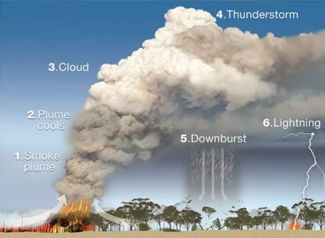
📸 Bureau of Meteorology
Why are they so dangerous?
Pyrocumulonimbus clouds can cause dangerous and unpredictable changes in fire behaviour, making the fire more difficult and hazardous to fight.
Change in fire direction and intensity:
These clouds can produce intense updrafts that suck in so much air that strong winds develop, drawn in from all directions towards the plume. These can cause the fire to burn hotter and spread faster. The inflowing winds can cause nearby fires (perhaps caused by spot fires or lightning strikes, see below) to change direction unexpectedly as they are drawn in to the parent fire
Spot fires:
The updrafts become very tall and because they are so strong they can carry large burning embers and lift them to great heights before they’re carried far downwind, where they can ignite new fires (called spot fires). During Victoria’s Black Saturday bushfires in 2009, one spot fire was recorded more than 30 km from the ‘parent’ fire.
Lightning:
Lightning can form in these storms, which can cause new fires. Again in Victoria’s Black Saturday fires, lightning from pyrocumulonimbus clouds started a new fire 100 km from the fire front.
Downbursts:
Rain can also form in pyrocumulonimbus clouds, producing intense downbursts (caused by cooling from evaporation of the rain) that hit the ground and ‘burst’ outwards, producing very strong and gusty winds that can last 20 minutes or more. These winds can be strong enough to blow the fire in any direction, and have been responsible for deaths of fire fighters on a number of occasions.
Information source: http://media.bom.gov.au/social/blog/1618/when-bushfires-make-their-own-weather/
Source
Copying/Pasting full or partial texts without adding anything original is frowned upon by the community. Repeated copy/paste posts could be considered spam. Spam is discouraged by the community, and may result in action from the cheetah bot.
More information and tips on sharing content.
If you believe this comment is in error, please contact us in #disputes on Discord
Downvoting a post can decrease pending rewards and make it less visible. Common reasons:
Submit
Hi! I am a robot. I just upvoted you! I found similar content that readers might be interested in:
http://media.bom.gov.au/social/blog/1618/when-bushfires-make-their-own-weather/
Downvoting a post can decrease pending rewards and make it less visible. Common reasons:
Submit
Congratulations @theloneisobar! You received a personal award!
You can view your badges on your Steem Board and compare to others on the Steem Ranking
Vote for @Steemitboard as a witness to get one more award and increased upvotes!
Downvoting a post can decrease pending rewards and make it less visible. Common reasons:
Submit