Canvas source Greetings, everyone! I’m thrilled to be here, diving into the first week of this exciting course on digital cartography. It feels like the start of an adventure where maps aren't just boring sheets of paper but gateways to understanding the world around us.
Today, I'm taking my first steps into the fascinating world of mapping. Honestly, I never thought I'd be this excited about learning how tiny lines and symbols can explain so much! But here I am, ready to explore.
So, buckle up! Whether it’s mastering coordinates or decoding map legends, I’m here to learn, laugh, and maybe get lost—just a little—before finding my way again. Let the fun begin!
Make a freehand map of your country (It can be on paper, a computer or on your cell phone, the only condition is that it must not be traced. That is to say: The map does not have to be perfect ) |
|---|
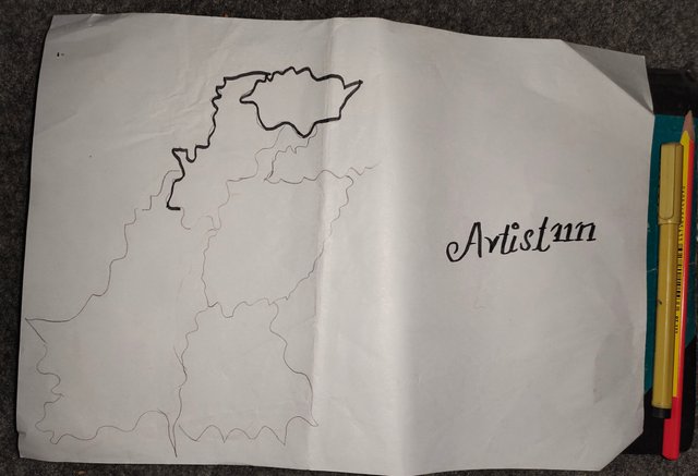 Step 1 Step 1 |
|---|
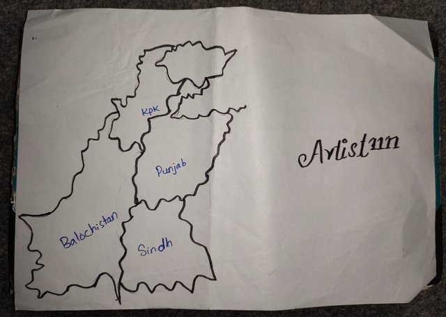 Step 2 Step 2 |
|---|
 |
|---|
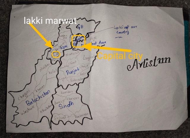
Inside the freehand map you made, locate where the capital of your country is and where the state / department / province where you live is. |
|---|
 |
|---|
On my freehand masterpiece of a map, I’ve proudly marked the capital, “Islamabad,” shining like a star in all its glory.
And, of course, I didn’t forget to point out where I belong—my beloved province, standing tall and proud.
Trust me, my map might not win awards, but it knows how to show off the essentials!
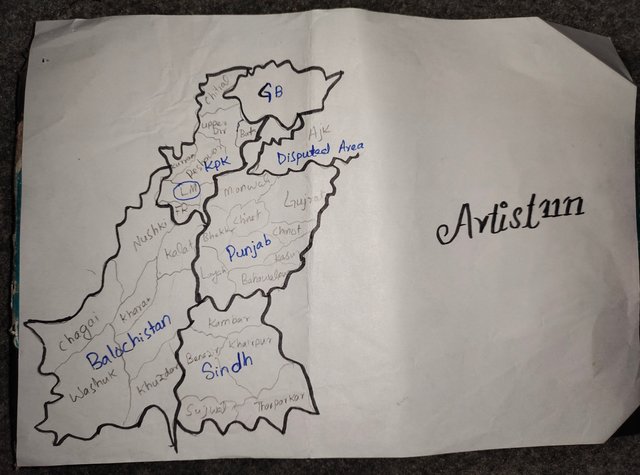
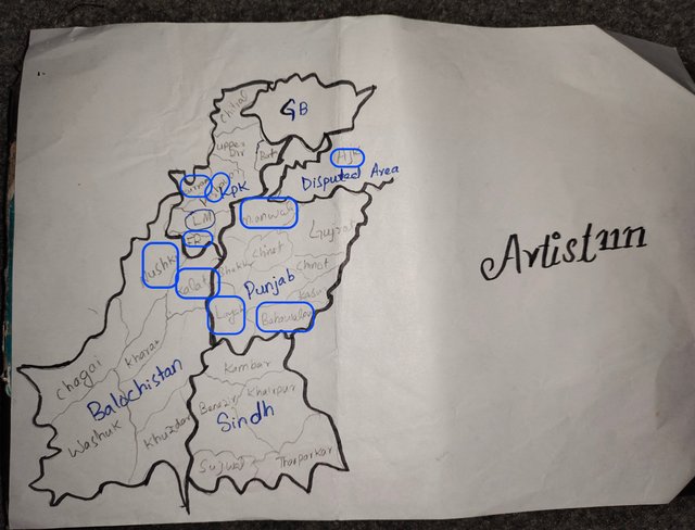
Locate within the map you made, some states / departments / provinces you know by heart (Only those you know / remember at the time, don't fool yourself by cheating) |
|---|
In my map, I didn’t go overboard. Our country has loads of cities, but I kept it simple and added just a few from each province. Why? Because sometimes less is more, and I wanted to let my creativity shine!
 |
|---|
Since we follow a province system, I focused on highlighting the top cities from each one. Think of it as my way of showing off my "map-making magic" without overwhelming you.
Oh, and here’s the fun part—I underlined the cities that hold a special place in my heart. They deserved the extra attention, don’t you think?
So, while my map isn’t winning any geography awards, it’s definitely got personality.
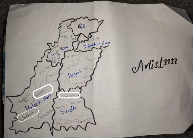
Mention 3 places that you do not yet know about your country and that you would love to know and why. |
|---|
Haha, this answer might surprise you all, but here it goes. Despite being a bachelor’s graduate and having studied geography from 5th to 8th grade (not to mention some extra knowledge along the way), I honestly had no idea about a few places in my own country!
 |
|---|
Take Kambar, Kahara, and Washuk, for instance. These names sound like they belong to some far-off, mysterious land! It's funny how, after all this time, I’m still discovering new cities in my own backyard.
I honestly thought I knew most places, but these cities turned out to be in different provinces I never paid much attention to. It’s a bit embarrassing, but hey, there’s always something new to learn, right?
I’d love to explore these places because every corner of our country has a unique story. And honestly, the idea of discovering these hidden gems has got me excited—there's always more to uncover!
Respond |
|---|
a) What is a map for you?
For me, a map is like a visual guide to understanding the world. It's more than just a drawing on paper or a screen; it's a tool that helps navigate, explore, and make sense of spaces, places, and directions. A map can tell a story about geography, history, or even a journey—whether physical or metaphorical. For me, a map is something very practical, but it's also an art work, as each line, symbol, and color holds a meaning.
b) In your opinion, what are the most relevant elements to understand a map and why?
In my opinion, the most relevant elements to understand a map are the scale, legend, coordinates, and symbols.
- Scale: It helps you understand the relationship between the map and the real world. Without it, we wouldn't know how far or close things are in reality.
- Legend: The legend explains what different symbols or colors on the map represent. It's essential to interpret the map correctly—without it, you'd be guessing about what the map is trying to communicate.
- Coordinates: These provide the exact location on the earth’s surface, which is crucial for finding specific places. Whether in geographic (degrees, minutes, seconds) or UTM (meters) format, they make maps precise and useful.
- Symbols: These conventional signs are universal, allowing us to quickly identify features such as roads, rivers, or mountains. Without them, it would be hard to make sense of a map's details.
C) In my opinion, cartography is or isn't so important for sure.
Cartography is very vital for us because it forms a basis for spatial understanding and the application of maps by us, whether for tourism, town planning, preserving the environment, or catastrophe and crisis management.
Cartography makes scientific study and historical account more real because it informs people on how places and environments change over time. With digital cartography, we can analyze and visualize vast amounts of data.
This is important in the world today for everything from climate change studies to urban development. Without cartography, we'd be walking blind, without the means to interpret and interact with our environment efficiently.
kind Regards
@artist1111

Adieu, folks!
May the winds of fortune
carry you to greatness!
May the winds of fortune
carry you to greatness!
Hola artist, éxitos en esta tarea.
Verificado en: 20-12-2024
Downvoting a post can decrease pending rewards and make it less visible. Common reasons:
Submit