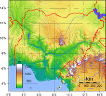
Nigeria's most expansive topographical region is that of the valleys of the Niger and Benue River valleys (which merge into each other and form a "y" shaped confluence at Lokoja ). [12] Plains rise to the north of the valleys. To the southwest of the Niger there is "rugged" highland , and to the southeast of the Benue hills and mountains are found all the way to the border with Cameroon .
Coastal plains are found in both the southwest and the southeast.
Niger Delta
This section needs expansion . You can help by
adding to it. (January 2011)
The Niger Delta is located in the southern part of Nigeria. It is one of the world's largest arcuate fan-shaped river deltas .
The riverine area of the Niger Delta is a coastal belt of swamps bordering the Atlantic ocean . The swamps are vegetated tidal flats formed by a reticulate pattern of interconnected meandering creeks and tributaries of the Niger River.
Vegetation of the Niger Delta
The vegetation of the Niger Delta consist mainly of forest swamps . The forest are of two types, nearest the sea is a belt of saline and brackish
Mangrove swamp separated from the sea by sand beach ridges within the mangrove swamp. Numerous sandy islands occur with fresh water vegetation. Fresh water swamps gradually supersede the mangrove on the landward side. About 70% of Nigeria's crude oil and gas production is from the area.
Rainfall in Niger Delta
Rainfall in the coastal belt of the Niger Delta is heavy due to the closeness of the Delta region to the equator. Annual rainfall totals vary from 2,400 to over 4,000 millimeters.
Niger Delta cities and their annually rainfall totals in millimeters:
Warri — 2,730 mm
Forcados (coastal town in the Niger Delta) — 4,870 mm
Port Harcourt — 2,400 mm
Calabar (coastal city) — 3,070 mm (rainiest city with over one million people in Nigeria)
Bonny (south of Port Harcourt) — 4,200 mm
Vegetation

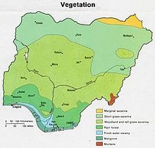
Vegetation map of Nigeria.
Nigeria is covered by three types of vegetation: forests (where there is significant tree cover), savannahs (insignificant tree cover, with grasses and flowers located between trees), and
montane land. (The latter is the least common, and is mainly found in the mountains near the Cameroon border.) Both the forest zone and the savannah zone are divided into three parts. [13]
Some of the forest zone's most southerly portion, especially around the Niger River and
Cross River deltas, is mangrove swamp (see
Central African mangroves ). North of this is fresh water swamp, containing different vegetation from the salt water mangrove swamps, and north of that is rain forest. [13]
The savannah zone's three categories are divided into mm' Guinean forest-savanna mosaic , made up of plains of tall grass which are interrupted by trees, the most common across the country; Sudan savannah, similar but with shorter grasses and shorter trees; and Sahel savannah patches of grass and sand, found in the northeast. [13]
https://steemit.com/hive-119812/@yaroharuna68/nigeria-topography
Downvoting a post can decrease pending rewards and make it less visible. Common reasons:
Submit
Thank you for sharing in Steem Geography! Your post has been selected for today as part of the Steemit Communities support Program.
I appreciate a lot your engagement with this community.
I’d love to hear more from you!!
Downvoting a post can decrease pending rewards and make it less visible. Common reasons:
Submit