000
WTNT35 KNHC 282043
TCPAT5
BULLETIN
Hurricane Dorian Advisory Number 18
NWS National Hurricane Center Miami FL AL052019
500 PM AST Wed Aug 28 2019
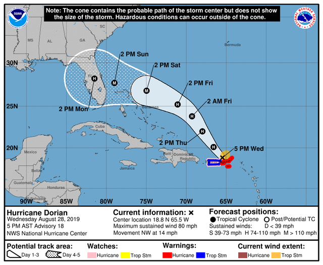
...DORIAN GRADUALLY MOVING AWAY FROM THE NORTHEASTERN CARIBBEAN
SEA...
...EXPECTED TO BECOME A DANGEROUS HURRICANE IN THE WESTERN
ATLANTIC...
SUMMARY OF 500 PM AST...2100 UTC...INFORMATION
LOCATION...18.8N 65.5W
ABOUT 45 MI...70 KM NW OF ST. THOMAS
MAXIMUM SUSTAINED WINDS...80 MPH...130 KM/H
PRESENT MOVEMENT...NW OR 320 DEGREES AT 14 MPH...22 KM/H
MINIMUM CENTRAL PRESSURE...997 MB...29.44 INCHES
WATCHES AND WARNINGS
CHANGES WITH THIS ADVISORY:
None.
SUMMARY OF WATCHES AND WARNINGS IN EFFECT:
A Hurricane Warning is in effect for...
- Vieques and Culebra
- U.S. Virgin Islands
- British Virgin Islands
A Hurricane Watch is in effect for...
- Puerto Rico
A Tropical Storm Warning is in effect for...
- Puerto Rico
For storm information specific to your area in the United States,
including possible inland watches and warnings, please monitor
products issued by your local National Weather Service forecast
office. For storm information specific to your area outside of the
United States, please monitor products issued by your national
meteorological service.
DISCUSSION AND OUTLOOK
At 500 PM AST (2100 UTC), the apparent eye of Hurricane Dorian was
located near latitude 18.8 North, longitude 65.5 West. Dorian is
moving toward the northwest near 14 mph (22 km/h). On this track,
Dorian should continue to move near or over the U.S. and British
Virgin Islands during the next several hours and then move over the
Atlantic well east of the southeastern Bahamas on Thursday and
Friday.
Maximum sustained winds have increased to near 80 mph (130 km/h)
with higher gusts. Dorian is forecast to strengthen and become a
powerful hurricane during the next few days over the Atlantic
waters.
Hurricane-force winds extend outward up to 15 miles (30 km) from the
center and tropical-storm-force winds extend outward up to 80 miles
(130 km).
The estimated minimum central pressure is 997 mb (29.44 inches).
HAZARDS AFFECTING LAND
RAINFALL: Dorian is expected to produce the following rainfall
accumulations:
Northern Leeward Islands...1 to 3 inches.
Eastern Puerto Rico, the the U.S. and British Virgin Islands...4 to
6 inches, isolated 8 inches.
Western Puerto Rico and the central and northwestern Bahamas...2 to
4 inches, isolated 6 inches.
Coastal sections of the Southeast United States...4 to 8 inches,
isolated 10 inches.
This rainfall may cause life-threatening flash floods.
WIND: Hurricane conditions are ongoing over portions of the U.S.
Virgin Islands, and could still occur over Vieques, Culebra,
and the British Virgin Islands during the next several hours. These
winds should subside tonight. Tropical storm conditions are
expected in Puerto Rico this afternoon and tonight.
Wind speeds atop and on the windward sides of hills and mountains
are often up to 30 percent stronger than the near-surface winds
indicated in this advisory, and in some elevated locations could be
even greater.
SURF: Swells are expected to increase later today across the U.S.
and British Virgin Islands and along the southern coasts of Puerto
Rico and Hispaniola, and they could cause life-threatening surf and
rip current conditions. Please consult products from your local
weather office.
NEXT ADVISORY
Next intermediate advisory at 800 PM AST.
Next complete advisory at 1100 PM AST.
$$
Forecaster Avila