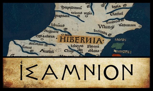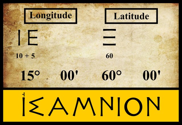
Continuing our voyage up the east coast of Claudius Ptolemy’s Ireland, our next landfall is ’Ισαμνιον [Isamnion]. The identity of this place is still the subject of much dispute. We do not even know whether Ptolemy classified it as a promontory or a settlement. Some manuscripts have ’Ισαμνιον ακρον [Isamnion Headland], while others have just ’Ισαμνιον. Ptolemy’s editor and Latin translator Karl Müller cites two early sources that suggest it was a town or settlement of some sort.
The first of these is Stephanus of Byzantium, a geographer of the 6th century CE. His Ethnica, an alphabetic gazetteer of ethnographic terms, survives only in scattered fragments and an abridged epitome by Hermolaus. Under the letter sigma, we find the following entry:
Samnion, Pretanic city. (Stephanus Byzantius 553)
Stephanus’s 19th-century editor August Meineke believed that he was referring to a place in modern Brittany, but Πρετανίας surely refers to the Πρετανοί [Pretanoi] or Priteni, the earliest Celtic inhabitants of Ireland and Britain, and the people from whom the name Britain probably derives (O’Rahilly 444 ff).
Müller’s second source is Marcian of Heraclea, a geographer of the 4th century CE. His Periplus of the Outer Sea, a sailing manual for the Atlantic Ocean, was also edited by Müller. In Book 2, Chapters 42 and 43, Marcian gives a brief description of Ireland, which includes the following:
It has 16 tribes, 11 principal cities, 15 principal rivers, 5 principal headlands, 6 principal islands. (Marcian 561)
11 cities and 5 headlands agrees with Ptolemy’s description if Isamnion is reckoned as a city [πολις] rather than a headland [ακρον]. Note, though, that Ptolemy has 20 tribes, not 16, and 9 islands, not 6. So it is possible that Isamnion is a headland after all, and Marcian’s reckoning is simply incorrect. No sources specifically identify Isamnion as a πολις. On the other hand, Stephanus’s Samnion does seem to be a variant of the same name, and it is unmistakably identified by him as a city.
Other than the absence of ακρον in some manuscripts, there are no significant orthographical differences between the sources. There are also no differences in the coordinates they assign to Isamnion.

Headlands
In the literature, Ptolemy’s Isamnion has been identified with at least five different locations: two settlements and three headlands. And these do not exhaust all the candidates that have been suggested in recent years.
In the early 17th century, William Camden called this feature Isanium and identified it with St John’s Foreland (St John’s Point), the headland at the eastern end of Dundrum Bay in County Down. He further surmised that its name derived from the British word isa, meaning lowest. The Old Irish word for low is ísel, the Old Welsh isel. In proto-Celtic the superlative form of an adjective was generally indicated by the suffix -isamo-. James Ware repeated Camden’s identification, and his editor Walter Harris understood his etymology to mean a low promontory.

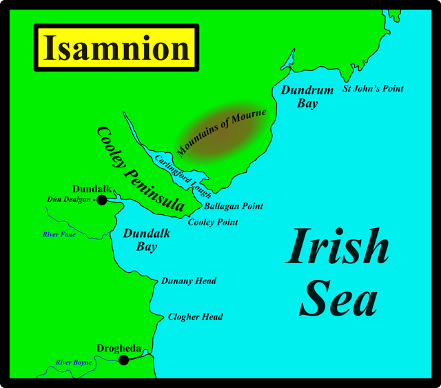
St John’s Point is roughly 65 km northeast of the Boyne estuary. On Ptolemy’s map of Ireland, Isamnion lies approximately north-northeast of the mouth of the Bouvinda, but the distance is only about 34 km—if we accept Ptolemy’s estimate that 5' of latitude in this part of the world corresponds to about 7.7 km, while 5' of longitude corresponds to half this distance (Ptolemy 1:7:1). There are also several notable features along this stretch of coast that are passed over by Ptolemy: for example, Clogher Head, Dunany Point, Dundalk Bay, Carlingford Lough and Dundrum Bay.
More recently, Charles Trice Martin (1892) and Darcy & Flynn (2008) have revived Camden’s identification of Isamnion with St John’s Point.
The headlands at the mouth of Carlingford Lough are about 34 km from the Boyne and would make a better fit—but only if we don’t rescale Ptolemy’s map. I showed in an earlier article that Ptolemy’s Ireland is significantly larger than the real thing and some rescaling is necessary if we wish to overlay the two. Nevertheless, at one least modern researcher, Gregory Toner (2002), has identified Isamnion with the Cooley Peninsula (Cúalnge), which lies between Dundalk Bay and Carlingford Lough. In the 19th century, Karl Müller suggested that if Isamnion were a promontory, the most likely candidate would be Cooley Point (Müller 79).
Louis Francis is alone in identifying Isamnion with Black Head in County Antrim. This headland is at the entrance to Belfast Lough. It lies north of the River Lagan, which is generally identified with another of Ptolemy’s landmarks, the mouth of the River Logia. The Bouvinda and the Logia are two of the few features on Ptolemy’s map of Ireland which linguistic and toponymic evidence allows us to identify with some certainty. But Francis’s analysis discards even these two clear-cut identifications. In my research I have found him to be consistently out of step with his fellow scholars.
Settlements
Two settlements have been linked to Isamnion: Dundalk and Emain Macha (Navan Fort). In his analysis of 1894, George Orpen suggests—somewhat tentatively, though—that Isamnion might be Dundalk, the ancient Dundealgan. The modern city of Dundalk takes its name from Dún Dealgan, a circular earthwork of uncertain age and origin on the western outskirts of the city. Much of the remaining structure is probably of recent provenance, but the presence of a standing stone nearby—known locally as Lia Lindgadain—testifies to the ancient age of the site.

This area is steeped in history and mythology. Ireland’s national epic Táin Bó Cúailnge is partly set on the Cooley Peninsula, and the hero of the Táin, Cúchulainn, is said to have been born here and to have resided in Dún Dealgan. Delga himself, after whom the dún is named, was a warrior of the Fir Bolg, the Bolgic Celts who colonized Ireland around 500 BCE (Joyce 268-269). According to other sources, however, he belonged to the Fomoire, a mysterious people of Irish mythological history (Monaghan 141). The Fomoire are generally depicted as wild and uncivilized, which suggests to me that they were based on the earlier and more primitive Celtic settlers of these islands, the hunter-gatherers known as the Priteni.
Orpen also considers the possibility that a trace of Ptolemy’s Isamnion may have survived in the Irish name for Island Magee, a small peninsula north of Belfast Lough, but he rejects it:
Its position negatives the identification with Rinn Seimhne, the ancient name for Island Magee, in Antrim. (Orpen 126)

About half a century later, T F O’Rahilly suggested another possible candidate for Ptolemy’s Isamnion:
Orpen, following Karl Müller, writes: “It is doubtful whether ’Ισαμνιον was a town or promontory, probably the former, as Marcian reckons eleven towns and five promontories in Ireland, which agrees with Ptolemy if Isamnium is taken as a town.” This view is confirmed by the existence of Emain, capital of Ulaid [Ulster], near the town of Armagh, which must be the place referred to. Emain might go back to *Isamonis or the like; the syncopated genitive Emna, would be analogical (cf. Lemain, gen. Lemna). (O’Rahilly 12-13)
O’Rahilly adds the following footnote to this analysis:
Since the above was first written, Pokorny has discussed the name [Zeitschrift für Celtische Philologie, Volume 21, p 127]. He identifies ’Ισάμνιον ἄκρον, “near Dundalk”, with Emnae, a name for the Otherworld, attested only in Immram Brain [The Voyage of Bran] (elsewhere Emain is used in this sense); and he suggests that Emain as the name of the Ulidian capital may have been originally *Emnae, later altered to Emain under the influence of emain [or emon], “a pair of twins”. (O’Rahilly 13 fn 1)
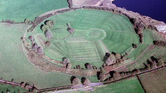
Emain Macha, or Navan Fort, is certainly a site of great importance, and it is undoubtedly of ancient standing. We would expect to find some reference to it in Ptolemy’s geography of Ireland. There is, however, one major flaw in O’Rahilly’s identification of Isamnion with Emain Macha: although it is doubtful whether Isamnion was a town or a promontory, every source of the Geography lists Isamnion among the features on the east coast of Ireland. Emain Macha, however, is an inland settlement situated about 55 km from the Irish Sea. This alone would seem to preclude against its identification with Isamnion. Ptolemy does document seven inland settlements, but they are placed in a separate list of their own after all the coastal features have been documented. Furthermore, it is my opinion that one of these is a better candidate for Emain Macha, as we shall see in due course.

Nevertheless, O’Rahilly’s theory has been endorsed by Alan Mac an Bhaird (1993) and Seán Duffy (2000).
A New Etymology
An alternative etymology has been recently advanced by the contributors to Roman Era Names:
Ισαμνιον ακρον (Isamnion 2,2,8) brings to mind many early river names across Europe that began with Is- (discussed under Isca), which probably came from PIE *ei- ‘to go’. For the –amnion part, Celticists favour a meaning like ‘under’ or ‘standing below’, though Latin amnis ‘river’ looks very similar. Either way, Ισαμνιον would make sense as derived from *Ισαμνιοι people living in a river valley under the very visible Mountains of Mourne. Identifying their ακρον would then depend upon the identity of Ουινδεριος [Vinderios, a river mouth north of Isamnion]: if it was Carlingford Lough or Dundalk Harbour, the headland leading to Ballagan Point and Cooley Point is most likely, whereas if it was the river Fane, Dunany Head or Clogher Point are better. (Roman Era Names)
Whatever the correct identification of Isamnion may be, there is a general consensus that the name is of Celtic origin.

| St John’s Point | Emain Macha (Navan Fort) | Dundalk | Cooley Peninsula | Black Head |
|---|---|---|---|---|
| Camden (1607) | - | - | - | - |
| Ware (1654) | - | - | - | - |
| Martin (1892) | - | - | - | - |
| - | - | Orpen (1894) | - | - |
| - | O’Rahilly (1946) | - | - | - |
| - | Mac an Bhaird (1991-93) | - | - | - |
| - | - | - | - | Francis (1994) |
| - | Duffy (2000) | - | - | - |
| - | - | - | Toner (2002) | - |
| Darcy & Flynn (2008) | - | - | - | - |
Source: Darcy & Flynn 57
References
- William Camden, Britannia, or, A Chorographical Description of Great Britain and Ireland, Together with the Adjacent Islands, Volume 2, Edmund Gibson, London (1722)
- Robert Darcy & William Flynn, Ptolemy’s Map of Ireland: A Modern Decoding, Irish Geography, Volume 41, Number 1, pp 49-69, Geographical Society of Ireland, Taylor and Francis, Routledge, Abingdon (2008)
- Louis Francis, Geographia, Selections, English : Ptolemy’s Geographia [Electronic Resource] : Books I & II, University of Oxford (1994)
- Walter Harris (editor), The Whole Works of Sir James Ware Concerning Ireland: Revised and Improved, Volume 2, S Powell, Dublin (1745)
- Patrick Weston Joyce, The Origin and History of Irish Names of Places, McGlashan & Gill, Dublin (1871)
- Marcian, Karl Müller (editor), Geographi Græci Minores, Volume 1, Firmin-Didot, Paris (1882)
- Charles Trice Martin, The Record Interpreter: A Collection of Abbreviations, Latin Words and Names Used in English Historical Manuscripts and Records, Reeves and Turner, London (1892)
- Patricia Monaghan, The Encyclodedia of Celtic Mythology and Folklore, Facts on File, Inc, New York (2004)
- Karl Wilhelm Ludwig Müller (editor & translator), Klaudiou Ptolemaiou Geographike Hyphegesis (Claudii Ptolemæi Geographia), Volume 1, Alfred Firmin Didot, Paris (1883)
- Karl Friedrich August Nobbe, Claudii Ptolemaei Geographia, Volume 2, Karl Tauchnitz, Leipzig (1845)
- Thomas F O’Rahilly, Early Irish History and Mythology, Dublin Institute for Advanced Studies, Dublin (1946, 1984)
- Goddard H Orpen, Ptolemy’s Map of Ireland, The Journal of the Royal Society of Antiquaries of Ireland, Volume 4 (Fifth Series), Volume 24 (Consecutive Series), pp 115-128, Dublin (1894)
- Claudius Ptolemaeus, Geography, Biblioteca Apostolica Vaticana, Vat Gr 191, fol 127-172 (Ireland: 138v–139r)
- Stephanus Byzantius, August Meineke (editor), Ethnica, Georg Reimer, Berlin (1849)
- James Ware, Walter Harris (editor), The Whole Works of Sir James Ware, Volume 2, Walter Harris, Dublin (1745)
- Friedrich Wilhelm Wilberg, Claudii Ptolemaei Geographiae, Libri Octo: Graece et Latine ad Codicum Manu Scriptorum Fidem Edidit Frid. Guil. Wilberg, Essendiae Sumptibus et Typis G.D. Baedeker, Essen (1838)
Image Credits
- Ptolemy’s Map of Ireland: Wikimedia Commons, Nicholaus Germanus (cartographer), Public Domain
- Greek Letters: Wikimedia Commons, Future Perfect at Sunrise (artist), Public Domain
- Dún Dealgan Motto: Thomas Wright (artist), Louthiana (1746), Public Domain
- Emain Macha (Navan Fort): © Ellen Bell, Fair Use
- Navan Fort Visitors’ Centre: Copyright Unknown, Fair Use
- St John’s Point, County Down: © Gloss Publications Ltd, Fair use

A very educated story I love always I read every detail of your stories friend..thanks to sharing for your valuable history of ireland history..very well done..my dear friend.. @harlotscurse best of luck of your work and i am always support your work..
Downvoting a post can decrease pending rewards and make it less visible. Common reasons:
Submit
thanks for sharing such great history..
like it..👍👍👍👍
god bless you.
@upvoted
Downvoting a post can decrease pending rewards and make it less visible. Common reasons:
Submit
there has many things to learn from you..
I am always appreciate your post..
👌👌👌✌👌
Downvoting a post can decrease pending rewards and make it less visible. Common reasons:
Submit
the history you share help me to learn about your country...
thank you dear..@harlotscurse
@upvoted
Downvoting a post can decrease pending rewards and make it less visible. Common reasons:
Submit
" really this history is awesome, i like your post D:) friend @harlotscurse , thank you for share this valuable post"
Downvoting a post can decrease pending rewards and make it less visible. Common reasons:
Submit
Really great history about ireland...
thanks for sharing this chronologically.
@upvote & @resteem has done..
Downvoting a post can decrease pending rewards and make it less visible. Common reasons:
Submit
I am feeling very happy man after reading your article Now
your article is all right but i have to say that
It is mind blowing article
Downvoting a post can decrease pending rewards and make it less visible. Common reasons:
Submit
i learn a lot of knowledge about ireland from your valuable post dear.. @harlotscurse
Downvoting a post can decrease pending rewards and make it less visible. Common reasons:
Submit
the natural beauty of ireland impress me dear...
thank you so much dear for such history..
@upvote done
Downvoting a post can decrease pending rewards and make it less visible. Common reasons:
Submit
your writing skills always best..because always writing very perfectly.its very good quality of you..you selecting very proper tropie for your post.its really new idea for me.thanks to sharing for your great article in your blog..very well done..my dear friend.. @harlotscurse best of luck of your great work and take care yourself.. keep it up..
Downvoting a post can decrease pending rewards and make it less visible. Common reasons:
Submit
i am lucky that i read such type of history only for your share.
thanks a lot.
@upvote done
Downvoting a post can decrease pending rewards and make it less visible. Common reasons:
Submit
wow! what a beautiful story I like your post thank you for sharing this post with us really this history is awesome
Downvoting a post can decrease pending rewards and make it less visible. Common reasons:
Submit
my intersting is grew to know more about such type of post only for you dear.
Downvoting a post can decrease pending rewards and make it less visible. Common reasons:
Submit
that's a great post about the history of ireland..
thanks a lot dear @harlotscurse for sharing with us such a great post..
@upvoted
Downvoting a post can decrease pending rewards and make it less visible. Common reasons:
Submit
Thank you for all the information you provide us about beautiful Ireland.
Downvoting a post can decrease pending rewards and make it less visible. Common reasons:
Submit
Very complete all the information, you did a good job writing this article I learned a lot
Downvoting a post can decrease pending rewards and make it less visible. Common reasons:
Submit
Dear...the history you share help me to learn about your country...
thank you dear..@harlotscurse
Downvoting a post can decrease pending rewards and make it less visible. Common reasons:
Submit
Great article about Ireland.More Unknown things knowing reading by this article. Thanks @harlotscurse
Downvoting a post can decrease pending rewards and make it less visible. Common reasons:
Submit
i learn a lot of history from you...
you are so much talented...
i like @harlotscurse
Downvoting a post can decrease pending rewards and make it less visible. Common reasons:
Submit
Excellent illustrations, I like the depth of your information congratulations.
Downvoting a post can decrease pending rewards and make it less visible. Common reasons:
Submit
I think you have to do lot more hard work to collect such type of amazing information
Downvoting a post can decrease pending rewards and make it less visible. Common reasons:
Submit
Very informative post.... overall good article written....❤️❤️
Downvoting a post can decrease pending rewards and make it less visible. Common reasons:
Submit
Fantastic post friend good job greetings
Downvoting a post can decrease pending rewards and make it less visible. Common reasons:
Submit
Downvoting a post can decrease pending rewards and make it less visible. Common reasons:
Submit
Greetings, good friend, I hope you come back soon, you do a great job, success
Downvoting a post can decrease pending rewards and make it less visible. Common reasons:
Submit
Greetings, good friend, I
Hope you come back soon, you do
A great job, success
- andreina89
I'm a bot. I detect haiku.
Downvoting a post can decrease pending rewards and make it less visible. Common reasons:
Submit
dear @harlotscurse this is really very valuable post i like you and your everything
Downvoting a post can decrease pending rewards and make it less visible. Common reasons:
Submit