Manuscript Tradition in Ptolemy’s Geography
Ptolemy’s Geography is served by an unusually rich manuscript tradition. More than fifty codices of this epochal work are extant. Some of these are mere fragments, and the oldest only goes back to the late 13th century (Berggren & Jones 42). The first printed edition in Greek was edited by Erasmus and published by Froben in Basel in 1533. Latin manuscripts first appeared during the Renaissance and a printed edition was brought out by Regiomontanus as early as 1475 (Ron 6.4). There was no Medieval Latin manuscript tradition of this work (Mintz).
Ptolemy is believed to have compiled the Geography around 150 CE. Needless to remark, his original manuscript has not survived. It is now thought that all extant manuscripts derive from a lost copy of Ptolemy’s autograph. This hypothesis is forced upon us by the fact that all extant manuscripts share a number of errors that are too egregious to have been introduced by Ptolemy himself: they must have been the work of a copyist, and probably included both transmissional errors and ill-considered emendations of Ptolemy’s text. Scholars have established that this copy was written in Greek capital letters, which implies that it was created no later than the 10th century (when Greek minuscule was adopted). This hypothetical copy was the forebear of all extant manuscripts (Berggren & Jones 42).
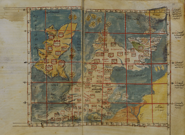
It appears that the Geography was lost during the Dark Ages, though fragments of it were preserved by the Arabs (Edson 114). In 1295 the Byzantine scholar Maximus Planudes discovered a copy of it in Constantinople. Planudes is believed to be responsible for the renewed interest in the work and the subsequent proliferation of manuscripts. It is also thought that he and his assistants adapted Ptolemy’s data to reconstruct the maps from scratch: none of the surviving medieval maps can be traced back to Ptolemy’s time (Diller). Textual analysis, however, has revealed that the extant manuscripts of the Geography fall into at least two different families, so they do not all derive from a single medieval source.
Recensions of the Geography
The final word has probably not yet been written on this subject, but currently scholars divide the fifty-odd manuscripts of the Geography into two broad families, or recensions, one of which is further divided into two subgroups.
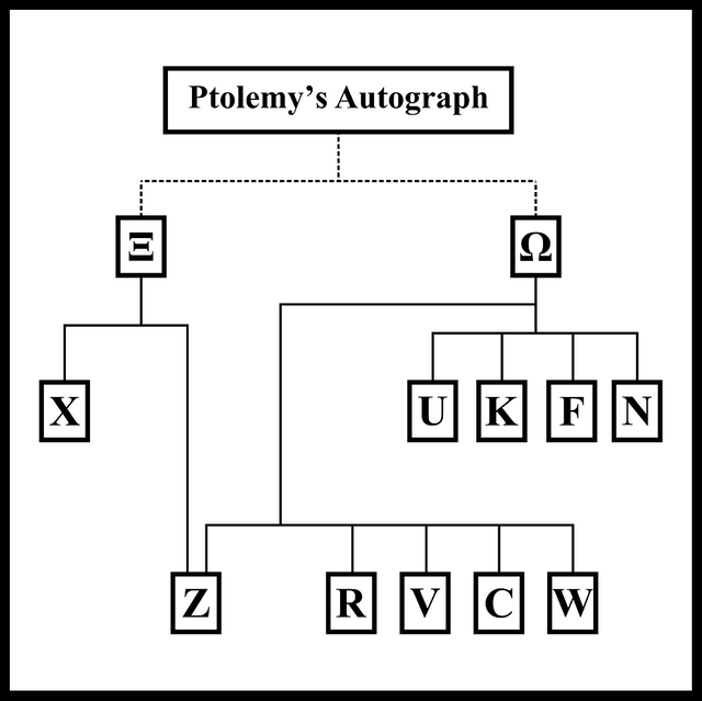
The present lettering system for manuscripts (Paul Schnabel, 1938; Stückelberger, Ergänzungsband, pp. 12-20) goes back to Wilberg. It may be noted that manuscripts denoted by a letter from the beginning of the alphabet (A, B, C, ...) are virtually absent from the set of important manuscripts. This reflects the fact that the manuscripts most easily available to early editors are now known to be of only secondary importance. (Hans van Deukeren)
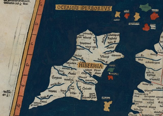
The Xi Recension (Ξ) is the oldest textual tradition. The earliest surviving member of this recension, X, or Vaticanus graecus 191 fol. 127-172, dates from about 1296. It is believed that this recension preserves a very ancient tradition, antedating the researches of Planudes by many centuries: a papyrus fragment dated to the early 3rd century is consistent with Xi but not with the other recension. Ptolemy’s description of Ireland is on folia 138v–139r.
Sometime in the 3rd century, if not earlier, Ptolemy’s text appears to have undergone a significant revision. This may have coincided with a transition from the use of papyrus rolls to parchment books, which took place in this century. From this revision originated the second major textual tradition, the Omega Recension (Ω). The manuscripts of this recension have been divided into two families: the Delta Group (Δ) and the Pi Group (Π). The progenitor of the Delta Group was possibly the manuscript discovered by Planudes. Copies of this manuscript were made by Planudes and his contemporaries in the decades after 1295. The Pi manuscripts are believed to be copies of a lost member of the Delta Group. The split between the Delta and Pi groups is believed to have occurred in the 5th or 6th century. The most important member of the Omega Recension is U, or Vaticanus Urbinus graecus 82.
Of the fifty-odd extant manuscripts of the Geography, only about a dozen are considered important:
| Siglum | MS | Recension | Date |
|---|---|---|---|
| X | Vaticanus graecus 191 fol. 127-172 | Xi | 1296 |
| Γ or A | Vaticanus Palatinus graecus 388 | XI | 15th Century |
| Z | Vaticanus Palatinus graecus 314 | XI | 1470 |
| ν or T | Burney 111 | Xi | 14th Century |
| V | Vaticanus graecus 177 | Omega: Pi | 14th Century |
| C | Supplementa graeca 119 | Omega: Pi | 14th Century |
| R | Marcianus graecus 516 | Omega: Pi | 14th Century |
| W | Vaticanus graecus 178 | Omega: Pi | 14th Century |
| N | Bodleianus 3376 | Omega: Delta | 14th Century |
| K | Seragliensis graecus 57 | Omega: Delta | Before 1300 |
| U | Vaticanus Urbinus graecus 82 | Omega: Delta | 1300 |
| F | Fabricianus graecus 23 | Omega: Delta | 14th Century |
| Σ | Laur. XXVIII 9 | ||
| B or Φ | Laur. XXVIII 38 |
Errors in Ptolemy’s Geography
Three principal kinds of errors—whether intentional or accidental—can be distinguished:
- Corrupted Figures
- Corrupted Text
- Misplaced Items
The manuscripts frequently differ in the spelling of place names and the coordinates they assign them. These variants should be examined when trying to identify Ptolemy’s locations. Fortunately, most modern editors of the Geography have collated the principal variants in their footnotes.
Corrupted Figures
The first of the three categories of errors listed above is surely the commonest. By its very nature, the Geography is a list of map coordinates for about 7800 locations in the known world. In the surviving manuscripts, these numbers are usually expressed as a combination of Greek lowercase letters (minuscule) and diacritical marks. Ptolemy recorded the latitudes and longitudes in degrees of arc and twelfths of a degree. (One twelfth of a degree, which equals five minutes of arc, was the smallest division he used in the Geography.) It is assumed that Ptolemy recorded these figures using the uppercase Greek letters that were still in use in the 2nd century.
In Müller (1883), the following letters or letter-combinations are used for degrees in the coordinates for Irish locations, the degree being indicated by the addition of a prime:
| Greek Letters | Number of Degrees |
|---|---|
| ζ′ | 7 |
| η′ | 8 |
| θ′ | 9 |
| ι′ | 10 |
| ια′ | 11 |
| ιβ′ | 12 |
| ιγ′ | 13 |
| ιδ′ | 14 |
| ιε′ | 15 |
| ιϛ′ | 16 |
| ιζ′ | 17 |
| ιη′ | 18 |
| νζ′ | 57 |
| νη′ | 58 |
| νθ′ | 59 |
| ξ′ | 60 |
| ξα′ | 61 |
| ξβ′ or ξϐ′ | 62 |
And the following symbols are used for fractions of a degree in the coordinates for Ireland, with a double prime added to indicate minutes of arc:
| Greek Letters | Fraction of a Degree | Minutes of Arc |
|---|---|---|
| ϛ′′ | 2 twelfths | 10 |
| δ′′ | 3 twelfths | 15 |
| γ′′ | 4 twelfths | 20 |
| L′′ | 6 twelfths | 30 |
| γο′′ | 8 twelfths | 40 |
| L′′δ′′ | 9 twelfths | 45 |
| L′′γ′′ | 10 twelfths | 50 |
I use “L” here for Müller’s unusual form of uppercase lambda, which I can’t find in any font. The following table records the numerals as Ptolemy probably wrote them:
| Number | Greek Letter | Letter Name |
|---|---|---|
| 7 |  | Zeta |
| 8 |  | Eta |
| 9 |  | Theta |
| 10 |  | Iota |
| 11 |   | Iota+Alpha |
| 12 |   | Iota+Beta |
| 13 |  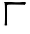 | Iota+Gamma |
| 14 |   | Iota+Delta |
| 15 |   | Iota+Epsilon |
| 16 |   | Iota+Digamma |
| 17 |   | Iota+Zeta |
| 18 |   | Iota+Eta |
| 20 |  | Kappa |
| 30 | 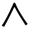 | Lambda |
| 40 | 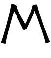 | Mu |
| 45 |   | Mu+Epsilon |
| 50 |  | Nu |
| 57 |   | Nu+Zeta |
| 58 |   | Nu+Eta |
| 59 |   | Nu+Theta |
| 60 |  | Xi |
| 61 |   | Xi+Alpha |
| 62 |   | Xi+Beta |
Several of Ptolemy’s ancient figures resemble one another, and the same can be said for the medieval or Byzantine numerals. It is easy to see how one figure might have been mistaken for another. Errors of this sort could have crept into Ptolemy’s text at any stage of the copying or printing of the work.
Corrupted Text
As Ptolemy and his medieval copyists used Greek letters to represent both text and numbers, orthographical errors in the text of the Geography are just as likely as numerical errors in the map coordinates. Most of the locations in the work were probably unknown to Ptolemy, and their native names were in strange languages—though Ptolemy’s practice was to Hellenize them.
When the true name of a place is known to modern scholars, they are in a position to correct a misspelling in Ptolemy. For example, every text of the Geography has Iamesa for the River Thames in Ptolemy’s description of Britain (van Deukeren). Obviously some early copyist misread Ptolemy’s tau (Τ) as iota (Ι), an easy thing to do. The Celtic name of the river was Tamesas, so there is no doubt that Tamesa is the correct form. It is unlikely that Ptolemy himself was responsible for this mistake.
But what is one to do with, say, Oboka, the name Ptolemy gives to a river in Ireland? This cannot be connected with any early river names, and it is not obviously Celtic, but any attempt to correct it must be highly speculative. Perhaps it does not require correcting. Perhaps that is exactly what Ptolemy wrote and exactly what the river was called two thousand years ago.
Misplaced Items
In addition to the textual errors in Ptolemy’s Geography, there are also geographical errors. One critic, writing of emendations made to Ptolemy’s text in the Middle Ages, notes:
These alterations seem to have been made due to discrepancies with the text and the maps drawn to the text’s specifications ... Examples of these discrepancies include cities being plotted in a sea and points along a coastline being plotted in reversed order. (Mintz)
If Ptolemy—or one of his copyists—could misplace locations in Italy (Cortona), how likely is it that his description of Ireland is free from similar errors? Unlike Italy, Ireland was never part of the Roman Empire.To Ptolemy, it was literally at the end of the known World, which is why he chose to begin his Geography with this remote little island. Whatever source Ptolemy used for his knowledge of Ireland, he is unlikely to have been in a position to appraise it or evaluate its accuracy.
These points should be borne in mind when trying to fit Ptolemy’s data to actual locations on the ground.
To be continued ...
References
- Daniel Mintz, Manuscript Tradition in Ptolemy’s Geography, JOC/EFR October 2007, University of St Andrews, St Andrews, Fife (2007)
- Evelyn Edson: The World Map, 1300-1492: The Persistence of Tradition and Transformation, The Johns Hopkins University Press, Baltimore, Maryland (2007)
- Hans van Deukeren, Ptolemy’s World, Online (2011-2017)
- Nathan Ron, Erasmus and Geography, Journal of Interdisciplinary History of Ideas, Volume 3, Issue 6, pp 6.1-6.29, GISI UniTO, Turin (2014)
- Karl Wilhelm Ludwig Müller (editor & translator), Klaudiou Ptolemaiou Geographike Hyphegesis (Claudii Ptolemæi Geographia), Volume 1, Alfredo Firmin Didot, Paris (1883)
- J Lennart Berggren, Alexander Jones, Ptolemy’s Geography: An Annotated Translation of the Theoretical Chapters, Princeton University Press, Princeton NJ (2000)
Image Credits
- Ptolemy’s Map of Ireland: Wikimedia Commons, Public Domain
- Map of Britain and Ireland: Wikimedia Commons, Codex Athous Vatopedinus 655: Add. MS 19391, f 19v-20 (British Library, London), Public Domain
- Family Tree of the Most Important Manuscripts: Self-Made, After Daniel Mintz

Thanks for the information this is so important for all the comunity of steemit thanks for sharing !!
Downvoting a post can decrease pending rewards and make it less visible. Common reasons:
Submit
Extraordinary history friend I loved very good maps and manuscripts left those heroes did a great job and now we can know things and the history of that time of 1533 too long ago, very good contribution so that we learn many thanks friend blessings
Downvoting a post can decrease pending rewards and make it less visible. Common reasons:
Submit
Thank you.
Downvoting a post can decrease pending rewards and make it less visible. Common reasons:
Submit
Greetings friend I hope you are well thanks for the support
Downvoting a post can decrease pending rewards and make it less visible. Common reasons:
Submit
very excellent post dear
Downvoting a post can decrease pending rewards and make it less visible. Common reasons:
Submit
upvoted you
and will be always with you
Downvoting a post can decrease pending rewards and make it less visible. Common reasons:
Submit
Thank you.
Downvoting a post can decrease pending rewards and make it less visible. Common reasons:
Submit
Mr.harlotscurse.
many many thanks just for you
always with you and reading your post regularly
Downvoting a post can decrease pending rewards and make it less visible. Common reasons:
Submit
thank you sir
am very grateful to you
Downvoting a post can decrease pending rewards and make it less visible. Common reasons:
Submit
great informative publication. I am a new follower. Greetings and I will be active with your publications
Downvoting a post can decrease pending rewards and make it less visible. Common reasons:
Submit
Thank you.
Downvoting a post can decrease pending rewards and make it less visible. Common reasons:
Submit
Waiting for new publications of yours. regards
Downvoting a post can decrease pending rewards and make it less visible. Common reasons:
Submit
excellent publication! not personally I was informed about the map and the manuscript in the year 1533. greetings
Downvoting a post can decrease pending rewards and make it less visible. Common reasons:
Submit
excellent information your publication can know more about the history of the years 1533 and much more.
Downvoting a post can decrease pending rewards and make it less visible. Common reasons:
Submit
informative
Downvoting a post can decrease pending rewards and make it less visible. Common reasons:
Submit
Thanks.
Downvoting a post can decrease pending rewards and make it less visible. Common reasons:
Submit
Excellent story, great friend, thank you, I love this post, thank you for the support and contribution, blessings, blessings
Downvoting a post can decrease pending rewards and make it less visible. Common reasons:
Submit
Thank you for your support and blessings.
Downvoting a post can decrease pending rewards and make it less visible. Common reasons:
Submit
Wow fascinating images of friend maps and manuscripts. regards
Downvoting a post can decrease pending rewards and make it less visible. Common reasons:
Submit
Excellent story friend I think without the manuscripts of Ptolemy would have lost much or almost all the geography of those years of 1533 was essential at that time what he could leave written and his maps so that we can in these times know all those maps and manuscripts thank you for sharing so extraordinary post greetings friend successful
Downvoting a post can decrease pending rewards and make it less visible. Common reasons:
Submit
Thank you for the comment.
Downvoting a post can decrease pending rewards and make it less visible. Common reasons:
Submit
Excellent post! I love learning new things really is interesting, thanks for sharing, greetings from Venezuela!
Downvoting a post can decrease pending rewards and make it less visible. Common reasons:
Submit
Thank you. Greetings from Ireland!
Downvoting a post can decrease pending rewards and make it less visible. Common reasons:
Submit
It was strange for me not to see him around here my dear friend, another incredible post on his part, very, very informative and this is the collective intelligence we need in Steemit, many blessings and to follow the good content in Steemit!
Downvoting a post can decrease pending rewards and make it less visible. Common reasons:
Submit
Thank you.
Downvoting a post can decrease pending rewards and make it less visible. Common reasons:
Submit
Great information, friend, come to this publication thanks to a Re-Smell. regards
Downvoting a post can decrease pending rewards and make it less visible. Common reasons:
Submit
Excellent and important post this information is very important for the community of steemit greetings and blessings good friend! Thanks for sharing (Y)
Downvoting a post can decrease pending rewards and make it less visible. Common reasons:
Submit
Thank you.
Downvoting a post can decrease pending rewards and make it less visible. Common reasons:
Submit
Dear @harlotscurse
How are you don't know? However, we believe there are good this is sincerely hope. Got a friend like you sortormot I am very happy in the world. Because your compassion has benefited me a lot it is a charsebarni for me.
To provide you with a vote from me and gave a flower gift please do take hope.
Because the gift that will please you the flattery.
But whatever the mind of man is a philosophical commentary of usakalet is of course another made it for.
The response waiting.
Be good, dear friend.
Invite you to visit my blog.
Downvoting a post can decrease pending rewards and make it less visible. Common reasons:
Submit
many many thanks just for you
salute boss
you are very great and Philentruper D
Downvoting a post can decrease pending rewards and make it less visible. Common reasons:
Submit
very interesting this publication that refers to the manuscripts of Ptolemy, was going through his profile Steemit and this was the one that caught my attention
Downvoting a post can decrease pending rewards and make it less visible. Common reasons:
Submit
i am so much happy to learn your post...you act like a teacher with us..
@upvote done
Downvoting a post can decrease pending rewards and make it less visible. Common reasons:
Submit
literature is the art, thanks for sharing
@upvote done
Downvoting a post can decrease pending rewards and make it less visible. Common reasons:
Submit
thanks for your great information.live you also like your post.God bless you
Downvoting a post can decrease pending rewards and make it less visible. Common reasons:
Submit
your post makes me happy.
thanks @harlotscurse
Downvoting a post can decrease pending rewards and make it less visible. Common reasons:
Submit
its an informative post...thank you so much..
@upvote done
Downvoting a post can decrease pending rewards and make it less visible. Common reasons:
Submit
good post dear.thanks for information
Downvoting a post can decrease pending rewards and make it less visible. Common reasons:
Submit
thanks a lot for informative post. keep it up
Downvoting a post can decrease pending rewards and make it less visible. Common reasons:
Submit
its a learing post..thank you @harlotscurse
@upvote done
Downvoting a post can decrease pending rewards and make it less visible. Common reasons:
Submit
good post dear...thank you..
@upvote done
Downvoting a post can decrease pending rewards and make it less visible. Common reasons:
Submit
thanks for that post
@upvote done
Downvoting a post can decrease pending rewards and make it less visible. Common reasons:
Submit
In the penultimate paragraph I forgot to replace the placeholder $$ with Iberia (Defaux 349). The reference is:
Downvoting a post can decrease pending rewards and make it less visible. Common reasons:
Submit
Excellent comment very good friend this I hope your next post always took us to fantastic times your stories are very interesting greetings
Downvoting a post can decrease pending rewards and make it less visible. Common reasons:
Submit
Thanks for notifying us.
Downvoting a post can decrease pending rewards and make it less visible. Common reasons:
Submit
thank you very much. You have a lot of talent and it's a great job that you do. regards
Downvoting a post can decrease pending rewards and make it less visible. Common reasons:
Submit