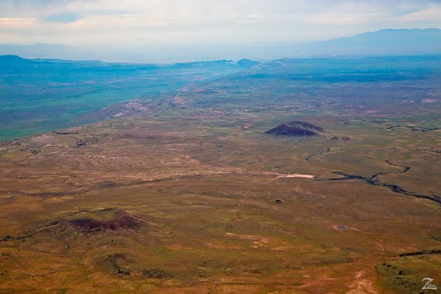
Two ancient cinder cone volcanos rise above the high desert of Black Rock, located on the Unikaret Plateau in southern Utah. The bottom left volcano is known as Maryland Knoll and the one to the top right is Antelope Knoll.
These are but 2 of the numerous volcanic remnants that are part of the the Uinkaret volcanic field that extends from the Toroweap fault in Toroweap Valley and Vulcans Throne and the Hurricane faults, which you can clearly see in this image above as Hurricane Cliff, which runs at an angle to the left of the volcanoes.
The Uinkaret volcanic field contains at least 213 volcanic cones and associated basaltic lava flows. Volcanic activity has been sporadic somewhat; The first volcanic eruptions began approximately 3.6 million years ago then at the end of the initial eruptive period, activity in the region was relatively quiet for approximately 2.6 million years.
Around 600,000 years ago prolific eruptive activity occurred for at least 100,000 years then continued less intensely until about 1,000 years ago.
(Research Source)
he Uinkaret Volcanic Field covers about 600 square miles (1,500 square km) extending about 50 miles (80 km) north from the Colorado River. The Uinkaret volcanic field is similar to the more familiar San Francisco Peaks volcanic field near Flagstaff, Arizona.
The volcanic features, basaltic cinder cones and lava flows, lie within the Canyon and on the Unikaret and Kaibab plateaus to the north. The cones and flows have formed in the last 2 million years.
(Research Source)
Ancient First Nations Tribes lived in the area when these more recent eruptions were occurring and some were apparently close to the action as Pottery shards dated to between A.D. 1050 and 1200 were found within the lava flow.
(Research Source)
To the north (top right in this image) are the mountains and valleys of Zion National Park and to the left below Hurricane Cliff is the Hurricane Valley.
I lensed this image while exploring the wilderness of the Uinkaret volcanic field in mid spring when the desert flora come alive after the spring rains awaken life!
This image is from my ongoing project in which I am trying to raise awareness of the 47% of the USA and 90% of Canada that remain unpopulated wilderness.
Where Eagles Fly - The American Wilderness Expedition is my personal mission to introduce people to these amazing locations that surround us.
If you like what you see here upvote then resteemit so that others may experience these wondrous places as well. And if you'd like these images to be part of your feed then follow me.
Yehaw!!

neverending landscape
Downvoting a post can decrease pending rewards and make it less visible. Common reasons:
Submit
Nice story.
Downvoting a post can decrease pending rewards and make it less visible. Common reasons:
Submit
Nice bro ...
Downvoting a post can decrease pending rewards and make it less visible. Common reasons:
Submit
This post is erupting!!
Downvoting a post can decrease pending rewards and make it less visible. Common reasons:
Submit
Get it!? Because of the volcanos
Downvoting a post can decrease pending rewards and make it less visible. Common reasons:
Submit
very nice story
Downvoting a post can decrease pending rewards and make it less visible. Common reasons:
Submit
nice photos
I really like your post
Downvoting a post can decrease pending rewards and make it less visible. Common reasons:
Submit
Great story and pic.
Downvoting a post can decrease pending rewards and make it less visible. Common reasons:
Submit