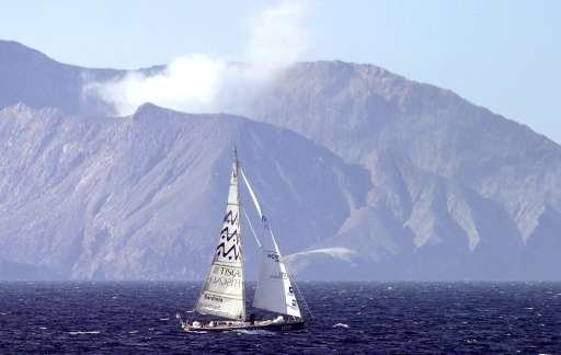
The vast underwater 'lost continent' of Zealandia extends from New Zealand north to New Caledonia and west towards the east coast of Australia

Scientists are attempting to unlock the secrets of the "lost continent" of Zealandia, setting sail Friday to investigate the huge underwater landmass east of Australia that has never been properly studied.
Zealandia, which is mostly submerged beneath the South Pacific, was once part of the Gondwana super-continent but broke away some 75 million years ago.
In a paper published in the Geological Society of America's Journal GSA Today in February, researchers made the case that it should be considered a new continent.
They said it was a distinct geological entity that met all the criteria applied to Earth's other continents, including elevation above the surrounding area, distinctive geology, a well-defined area and a crust much thicker than that found on the ocean floor.
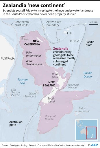
Covering five million square kilometres (1.9 million square miles), it extends from south of New Zealand northward to New Caledonia and west to the Kenn Plateau off Australia's east.
Drill ship Joides Resolution will recover sediments and rocks lying deep beneath the sea bed in a bid to discover how the region has behaved over the past tens of millions of years.
The recovered cores will be studied onboard, allowing scientists to address issues such as oceanographic history, extreme climates, sub-seafloor life, plate tectonics and earthquake-generating zones.

Map showing the Zealandia 'new continent', a massive underwater landmass in the South Pacific that has never been properly studied.
Co-chief scientist Jerry Dickens, from Rice University in Texas, said the region was a vital area to study changes in global climate.
"As Australia moved north and the Tasman Sea developed, global circulation patterns changed and water depths over Zealandia fluctuated," he said.
"This region was important in influencing global changes."
Australian National University's Neville Exon said the two-month expedition, setting out Friday from Townsville, would also help better understand major changes in the global tectonic configuration that started about 53 million years ago.
This is around the time that the Pacific "Ring of Fire", a hotspot for volcanoes and earthquakes, came into existence.
In the February scientific paper, lead author Nick Mortimer said experts had been gathering data to make the case for Zealandia being a continent for more than 20 years.
But their efforts had been frustrated because most of it was hidden beneath the waves.
"If we could pull the plug on the oceans, it would be clear to everybody that we have mountain chains and a big, high-standing continent," he said at the time.

과학자들은 제대로 연구 된 적이없는 호주의 동쪽에있는 거대한 수중 덩어리를 조사하기 위해 금요일에 항해를 시작한 뉴질랜드의 "잃어버린 대륙"의 비밀을 풀려고하고있다.
남태평양 아래에 주로 잠긴 뉴질랜드 (Zealandia)는 이전에 곤드 와나 (Gondwana) 대륙의 일부 였지만, 7 천 5 백만년 전에 부서졌습니다.
2 월 지질 학회지 GSA 투데이 (Geological Society of America) 지에 발표 된 논문에서 연구자들은 새로운 대륙으로 간주되어야한다고 주장했다.
그들은 그것이 주변 지역 이상의 고도, 특유의 지질학, 잘 정의 된 지역 및 해저에서 발견되는 것보다 훨씬 두꺼운 지각을 포함하여 지구의 다른 대륙에 적용되는 모든 기준을 충족시키는 별개의 지질 실체라고 말했다.
500 만 평방 킬로미터 (190 만 평방 마일)에 이르는이 섬은 뉴질랜드 북부에서 뉴 칼레도니아까지, 서쪽에서 호주 동부의 켄 고원까지 확장되어 있습니다.
드릴 우주선 Joides Resolution은 지난 수천만 년 동안 그 지역이 어떻게 행동했는지 발견하기 위해 해저에 깊이 놓인 퇴적물과 암석을 복구 할 것입니다.
회수 된 코어는 선상에서 연구되어 과학자들이 해양 역사, 극한 기후, 해저 해양 생물, 판 구조론 및 지진 발생 지역과 같은 문제를 해결할 수 있습니다.
텍사스의 라이스 대학 (Rice University)의 공동 수석 과학자 인 제리 디킨스 (Jerry Dickens)는이 지역은 지구 기후 변화를 연구하는 중요한 영역이라고 말했다.
"오스트레일리아가 북쪽으로 이동하고 태즈 만 해가 발달하면서 세계적인 순환 패턴이 바뀌었고 뉴질랜드의 수심이 변동했다"고 그는 말했다.
"이 지역은 세계적인 변화에 영향을 미치는 데 중요했습니다."
호주 국립 대학교의 네빌 엑손 (Neville Exon)은 타운 즈빌에서 금요일에 시작된 2 개월간의 탐험은 약 5 천 3 백만 년 전부터 시작된 지구 구조 구조의 주요 변화를 더 잘 이해할 수 있다고 말했다.
이것은 화산과 지진의 핫스팟 인 태평양의 "Ring of Fire"가 생겨 났을 무렵입니다.
2 월 과학 논문에서 수석 저자 인 닉 모티머 (Nick Mortimer)는 전문가들이 20 년 이상 동안 뉴질랜드가 대륙이 된 사례를 만들기 위해 데이터를 수집하고 있다고 말했다.
그러나 그것들의 대부분은 파도 아래에 숨겨져 있었기 때문에 그들의 노력은 좌절되었습니다.
"우리가 바다 위의 플러그를 뽑을 수 있다면, 우리는 산 사슬과 커다란 대륙을 가진 대륙을 가지고 있음이 모두에게 분명 할 것입니다.
