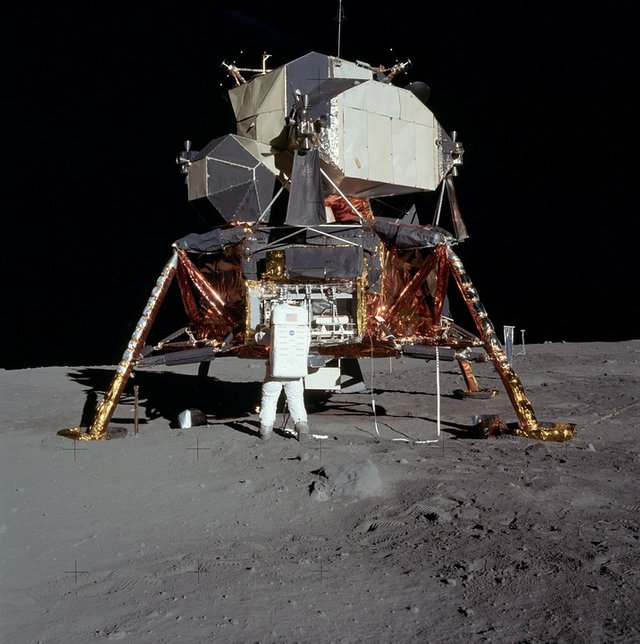
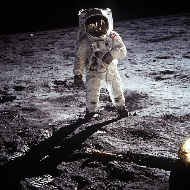
Apollo 11 is the icon of a phenomenal lunar human landing. The names Neil Armstrong and Edwin Aldrin, a pair of Apollo 11 astronauts who got the task of landing on the Moon, also soared even though true there are 10 other astronauts who also ever stepped on the surface of Earth's natural satellite. That popularity continues to survive until many years later, even after Armstrong passed away in 2012 ago.

Apollo 11 is part of the Apollo program, a US-funded political project in response to the challenges posed by the Soviet Union in a space race that is part of the cold war between the two superpowers. Before Apollo 11 was in the air, the US had lost everything. They have missed out on launching the first astronauts into the sky, the first female astronauts, and the first spacewalkers. They were left behind in the launch of the first satellite, the first Moon investigator, and the first lunar landing craft as well. These setbacks infuriated President John F. Kennedy who had not been so concerned with exploring the sky when he was still a senator. So he also declared the United States should be able to land a man to the Moon and bring it home safely before 1970 began. As a manifestation, NASA was built and supplied funds in very large amounts. At the peak of funds received by NASA is even equivalent to 4% of the value of the US State Budget 1966. The ambition that is carried by Apollo 11.
Apollo 11 slid from runway 39 in Kennedy space center complex located on Merritt Island, Florida Peninsula (USA) on July 16, 1969 with a giant rocket rocket Saturn V. So this rocket's powerful rock so that the vibrations generated when pouring all energy to take off recorded to all corners of the continental US by earthquake measuring instruments (seismometer). In 12 minutes later Apollo 11 had orbited the Earth in a low orbit with a height of only 170 km from the Earth's surface. After the entire crew ensured that all of the Apollo 11 instruments were functioning normally they soared to the Moon within 2.5 hours. It took up to 73 hours before Apollo 11 managed to orbit the Moon smoothly.
And the historic landings took place on 20 July 1969 at 20:17 UT (GMT) which took the location of Mare Transquilitatis. This landing was preceded by a thrilling drama that kept mission control officers in Houston, Texas (USA) holding their breath. A bit of a technical error makes the Moon module fly beyond the planned landing point. And as Armstrong watched his Moon module hovering low over the plains of rocks in the West crater (180 meters in diameter) which became an alternative point of landing, he instantly took over the semi-automatic control to manual. He also flew the Moon module even further with a very small amount of fuel. The landing eventually took place west of the Little West crater precisely at the latitude of 0.674 LUB (north latitude of the Moon) and longitude 23.473 BTB (east longitude of the Moon). This landing point strayed to 6 km from the originally planned. Due to this shift, the rest of the landing fuel in the module of the Moon is thin enough, ie only for 25 seconds only. And it took another 6.5 hours before Armstrong set his feet on the softer Moon soil, which was "as smooth as a powder," Armstrong recalled later.
Together with Aldrin, he installed a solar moon seismometer measuring instrument, installing a number of special black and white television cameras that allowed mission controllers to monitor their activities on the Moon, installing retroreflector mirrors for measurements of Earth-Moon distances with extremely high accuracy, a memorial plaque at the feet of the Moon module and do not forget to put a US flag on a special pole. For 2.5 hours later Armstrong and Aldrin explored the land of the Moon. Armstrong walked, precisely jumping up and down, up to 60 meters away to the edge of the Little West Crater. While Aldrin collects Moon rocks that have been broken down with geological hammers and Moon soils that are shoveled into special tubes. Overall they take 21.5 kg of rock and Moon land. Inside these rocks later discovered a number of distinctive minerals. One of them is a rich mineral Titanium that is named Armalcolite, taking the front letters Armstrong, Aldrin, and Collins. Had been struck by anxiety trapped on the surface of the Moon forever when Aldrin accidentally breaks the switch to turn on the top engine of the Moon module which is the only way to get back to Earth, Armstrong is innovatively using the tip of his pen to activate the damaged switch. And finally, they returned to Earth with happy.
LRO
The Apollo 11 landing left a lot of hardware left behind on the Moon's surface to make it easy to get back to Earth. The largest is the bottom of the Moon module in the form of large tubes of 4.3 meters in diameter supported by 4 feet so as to have a stretch of up to 9.5 meters. There is also a seismometer and retroreflector. For years and years there's always a question, get us on Earth to watch the devices again?
Before 2009 the answer was impossible despite using even the strongest telescope. Based on light diffraction theory by using the criteria of Dawes, then to be able to see the object diameter of 4.3 meters on the surface of the Moon ideally need a giant telescope with an objective mirror diameter of 46 to 53 meters working on the spectrum of visible light with a wavelength of 5500 Angstrom.
Please note that the Dawes criteria require ideal conditions. In non-ideal conditions, the diameter of the telescope can be twice as large as the ideal. In other words, we need a telescope with a giant mirror 92 to 106 meters in diameter to be able to see the bottom of the Apollo 11 module in the Moon. Until now humans do not have a telescope that size.
On the other hand, technological developments do allow telescopes with smaller, objective mirrors to detect celestial bodies the size of the lower half of Apollo's Moon module 11. This is shown by a 1.5-meter telescope at the Observatory of Lemmon Mountain, Arizona (USA) which forms the backbone of the Catalina celestial program Sky Survey. The semi-automatic telescope with the CCD camera successfully captured the 2014 AA asteroid (diameter ~ 3 meters) and the 2008 TC3 asteroid (~ 4 meter diameter) though both are still 500,000 km from Earth or rather than the Moon.
But photographing (image) objects that float freely in the sky against the background of the stars is very different than objects that exist on the surface of the Moon, although both are the same diameter. The Moon's soil is so bright that it reflects sunlight in a considerable quantity which makes it quite bright when photographed. This nature that underlies the shooting on the surface of the Moon by Apollo 11 astronauts takes place with the exposure time (exposure) of the camera is quite short. For if too long then the shots will only be a white color evenly in all parts along with the saturation of light, ie too many photons that caught the camera to far beyond the threshold. This is what makes the stars in the sky of the Moon never seen, whether in photographs made by Apollo 11 astronauts more than 40 years ago or in recent photographs of Moon explorers like Yutu robots and Chang'e 3 (Chinese) landers. These properties also make shooting the rest of the Apollo 11 module to be impossible to do with the sky celestial telescope Catalina Sky Survey or the like. Much different from the detection of foreign asteroids that are near Earth, which is done with time exposure camera is large enough, ranging from 30 seconds to more than 2 minutes. Until then the impossibility of observing the remaining devices of Apollo 11 with all the instruments of the Earth made this mission and also the subsequent Apollo missions culminated in conspiracy theorists.
The situation changed dramatically in 2009 when the US launched the LRO (Lunar Reconnaissance Orbiter) satellite to map the Moon with a very high resolution that has never been in its history. The LRO satellite circles the Moon since June 23, 2009, in an oval polar orbit with the perilune (the closest point to the Moon) only 30 km above the surface of the Moon while the apolune (farthest point to the Moon) is 216 km above the surface of the Moon. In just two years the satellite has produced very large data up to more than 192 terabytes. For comparison, Hubble's ground-based telescope only produces about 45 terabytes of data during the first 20 years of its operation. The surface image of the Moon in this very large number which then form the global map of the latest Month. The resolution of this map averages 100 meters per pixel, but for certain areas, the resolution is very high up to 0.5 meters per pixel according to the LRO camera capabilities at the point of perilune.
Successful LRO followed by Chang'e 2 (China) satellite that started orbiting the Moon since October 6, 2010. Chang'e 2 camera also has a very high resolution up to 1 meter per pixel. Chang'e 2 also managed to form a global map of the high-resolution Moon, which became the basis for Chang'e 3 landing mission and robot explorer Yutu in December 2013 then. The difference is that the Chang'e 2 satellite does not last long on the Moon like the LRO satellite. He left the Moon on June 6, 2011, to continue his journey towards asteroid 4179 Toutatis.
Another difference, the Moon map produced by Chang'e 2 mission is secret and can only be accessed by limited circles in China, especially the military. Instead, the LRO mission product map is available to the public until the resolution limit is high enough and accessible to anyone who wants it. While these maps are not as popular as earth maps like Google Maps or similar map pages as are programs like Google Earth, the LRO LST mission product map is relatively easy to navigate up to a certain level of resolution. Even the Moon map also presents an option to obtain a higher resolution image of the Moon. Two of the LRO mission product maps are QuickMap and WMS Image. The availability of the Moon maps allows us to track the traces left by Apollo 11 on the Moon.
Current Traces
Here the author uses the WMS Image map presented by School of Earth & Planetary Exploration at Arizona State University, Arizona (USA). This map provides options for tracing the surface of the Moon at desired coordinates and at a higher resolution than 100 meters per pixel by utilizing menus such as "Map Options" and "Layers". When the WMS Image map page is opened, it will display the menu "Map Options". In this menu, there is a subjection "Projection", which needs to be selected as "Orthographic", while sub-menus "Latitude" and "Longitude" (longitude) are written respectively +0,674 and +23,473. Next sub-menu "Single-click action" we select "Get footprint info."
Switch to the "Layers" menu, open the LROC NAC Data sub-menu and check the "No NAC footprints" option. Once filled/marked, slide the two menus downward by using the cursor so as not to interfere with our view of the map of the Moon immediately presented. Then hover over the navigation bar to the left of the screen to zoom into the maximum. As soon as the scale bar (in the lower left corner) shows the number 6 km or less, refer back to the "Layers" menu on the "LROC NAC Data" sub-menu and now check the box in front of the "LROC NAC overlay option (available only at 100 m / px or closer). "
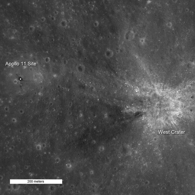
After the menus are filled in and the resolution continues to be enlarged gradually, then when the scale bar shows the 4 km figure we can already identify the position of the West crater which is located right in the middle of the map, although only as a hole that is quite small compared to other large craters sprinkled around it. What distinguishes, the West crater looks steeper than most of the other craters, indicating that the crater is a young crater (in geologic time scale). As a young crater, the crater structure of the West is still ornately adorned with pieces of ejecta material in various sizes that make it not the ideal place for human land. So why did Armstrong decide to continue flying its Moon module westward beyond this rocky plain can be understood, although it poses great risks as very limited amounts of landing fuel in the Moon module.
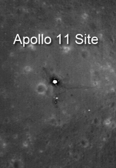
When resolutions are back up, Little West crater begins to appear as a small spot when the scale bar shows the figure of 1700 meters. When enhanced again, the crater becomes more visible and shows the same features as the West crater as a young crater, only much smaller in diameter. By the time the scale bar is at the 700-meter mark, the bottom of the Apollo 11 moon module begins to appear even as a small spot that is difficult to distinguish from other Moon surface features around it. But only at the greatest resolution, ie when the scale bar shows the number 200 meters, just the bottom of the Moon module is clearly visible. Towering as high as 3 meters beneath the sun-skewed sunlight shapes clear enough, the bottom of the Apollo 11 Apollo 11 module is quite prominent in the middle of its surroundings. Vaguely Armstrong's footsteps heading east (towards the edge of the Little West crater) and then back again to install a seismometer and a reflore reflector mirror was visible.
If we point the cursor at the coordinate point where the bottom of Apollo 11 Apollo 11 module is located and clicked, it will display "Query Results" menu showing LRO images ever taken for the area around the coordinates. We can choose one of them for example image labeled M129133239R. This image was taken by LRO satellite on May 21, 2010 at 19:06 UT (GMT) when the satellite is located at an altitude of 40 km from the surface of the Moon. By enlarging the resolution and tracking the position of the Apollo 11 Moon module, we will get more details on the bottom of this module of the Month. It is seen as a shaded little tube supported by three legs (the fourth leg is invisible). From it stretches the irregular lines to the crater of Little West to the east, which is Armstrong's footsteps. The irregular lines also look southward, the point at which Armstrong and Aldrin put the seismometer and retoreflector mirror. Both instruments can be identified. When the WMS Image map view is compared to the sketches of the landing site situations made by Armstrong and Aldrin, it is clear that the map view has some similarities to the sketch.
So is Apollo 11 really landing on the Moon? When searching by using WMS Image Image of LRO mission product we can answer with certainty. Yes!
Best Regard @t4r1
Reference :
https://airandspace.si.edu/explore-and-learn/topics/apollo/apollo-program/landing-missions/apollo11-landing-site.cfm
https://www.nasa.gov/mission_pages/LRO/news/apollo-sites.html
https://www.nasa.gov/mission_pages/apollo/revisited/index.html#.WsGY5Ze-nIU
https://history.nasa.gov/SP-4029/Apollo_11a_Summary.htm
https://www.space.com/16758-apollo-11-first-moon-landing.html
https://wiki2.org/en/Apollo_11


Good article @t4r1, just one thing I had trouble see the Apollo 11 image unless I clicked through to wikicommons. Anyway here it is cropped.

Downvoting a post can decrease pending rewards and make it less visible. Common reasons:
Submit
I'm having a hard time looking for images that have permission.... :)
thanks @terrylovejoy
Downvoting a post can decrease pending rewards and make it less visible. Common reasons:
Submit
Being A SteemStem Member
Downvoting a post can decrease pending rewards and make it less visible. Common reasons:
Submit