Hello Steemit folks! Yeah it seems I absconded for a while since my last post on here. Actually had to go for a compulsory orientation camping program that deprived me of the love of my life. It’s really had having to live alone for close to a month without the love of your life and I really wonder how people survive long distance relationships. Well, Good news is I’m back with my lovely laptop and this baby is rearing to go! I’ve so missed posting on here and I’m continuing with my series on getting to the summit of Mount Everest.
This is actually the third and final part of the mini-series which I was unable to conclude before fate separated me from my dear laptop for a while. The first installment of the series, Getting to know the Sagarmatha and the second, Understanding Mountaineering are equally as interesting and very vital to what you are about to read, in case you missed out on them before.
Let’s Talk
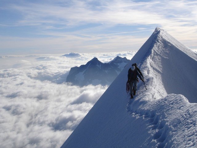 walking-on-the-edge-of-the-world
(Labelled for reuse]: W-W
 Not everyone will ever be able to climb to the highest point on earth. Physically. The average cost of a fully guided expedition to the peak of Mt. Everest averages between $40, 000 from the more difficult north col to $65,000 through the south col. People like me don’t even earn close to one-fifth of that in a year. And even amongst the lot that might be able to afford it , many are really put off by the life-threatening risks and hazards that awaits one in the heights of the Himalayas.
Like I have discovered during the course of writing this series from the likes of @greenrun and @insightout, not everyone really wants to. So well, at least everyone would prefer to read (let us please assume this is true for this one time) and reading our way through to the top of Mt. Everest is what we have tried to achieve with this mini-series.
Okay people, here we are… at the third and final part of what has been a short but quite eventful reading journey. At this point, we are at the end of the beginning as we are at the beginning of the end. You have learnt quite a handful about the Sagarmatha – the highest point on earth, we have also learnt one or two things about Mountaineering, which obviously is a very necessary knowledge to have for such a course as climbing Mt. Everest. All the physical and mental resources you have exhausted in preparing for this expenditure are about to be put to the test. Right now, you have a mountain in front of you; the tallest in the world, standing between you and glory. You have to make this moment count. You have to do it for all the fallen heroes before you. You have to… wait! I think I need to shut the hell up right now. Sorry I get a little carried away at times. Let’s get climbing.
The North and South Col
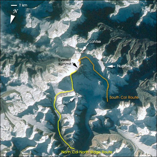 North and South Col routes to the summit
(License: Public Domain, Author: NASA]: Wikicommons
 The best time of the year to attempt to climb Mount Everest has been observed to be in the Month of May. This is because it is the period where monsoons push the jet streams away from upper parts of the mountains to lower the average wind speeds at such elevations. Monsoons are strong winds associated with heavy rainfall while Jet streams are strong narrow winds that travel in the upper parts of the atmosphere and are powerful enough to throw climbers off the mountain. Temperatures range from a severely cold 17 degrees Celsius below zero (i.e. -17oC) at the beginning of the year to around 3 degree Celsius below in the summer.
There are two major routes which are used to climb to the top of Mount Everest: the North Col (Through the Tibet autonomous region of China) and the South route (Through Nepal). The South Col route (Also Southeastern ridge) is the most commonly used due to its relative ease and speed of climbing. This was the route taken by Edmund Hilary and Tenzing Norzay to become the firsts to get to the summit of the mountain in 1953 and that is the route that we would be considering today.
The North route, on the contrary, involves more technical difficulty while climbing and it is a relatively longer route to and fro the summit. The major dangers presented on the South Col are the Khumbu Icefall and the Western Cwm, which were discussed briefly in the first installment of the series. There are 15 different routes and route variations in total that can be taken to the summit of Mount Everest.
The East Face, Everest’s biggest, is rarely climbed. An American team made the first ascent of it in 1983, and Carlos Buhler, Kim Momb, and Lou Reichardt reached the summit. Source
Through the South Col
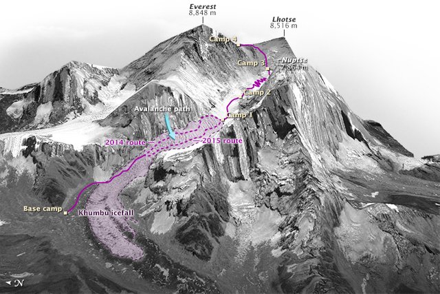 South Col route showing Khumbi Icefall and the various camp locations
(License: Public Domain, Author: NASA]: Wikicommons
 The ascent through the south col requires climbers to make use of five different camps which are established vertically at strategic positions along the route, each camp distancing from the other at about 450 m (1,500 ft). These camps are designated as the Base Camp, Camp I, Camp II, Camp III and Camp IV (which is closest to the summit of the mountain).
The ascent starts with a six to eight days trek from the Kathmandu valley in Nepal, south of the mountain to the Base Camp which is at 5,380 m (17,700 ft). This hike to the base camp allows for us to acclimatize to high altitudes in order to prevent altitude sickness; which was discussed in the previous installment as health-threatening conditions such as hypoxia, High-altitude cerebral edema (HACE) and High-altitude pulmonary edema (HAPE) that are associated with low-oxygen levels at very high altitudes. The temperatures tend to drop by about 1.5 degrees Celsius with every 150 m increase in elevation as one goes up the mountain.
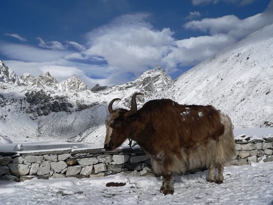 A Yak
(License: CC-BY-2.0, Author: Mahatma4711]: Wikicommons
 Native Yaks and dzopkyos (yak-cow hybrids) are used to transport supplies and equipment for climbers through the base camp to the Khumbu Icefall and upon getting there, Sherpas and some of the expedition climbers set up ropes and ladders to traverse this area while we continue acclimatizing (adjusting) to altitude. This acclimatization to altitude must be done for at least four weeks around the base camp before any attempt to get to the summit.
Now we have to cross the Khumbu icefall from the base camp. Passing through the Khumbu icefall from the Base camp is the most dangerous aspect of taking the south route. This icefall, which is at an elevation of 5,486 m, is a moving glacier mass that consists of huge tumbling blocks of ice, Seracs and crevasses which have claimed the lives of many climbers and Sherpas over the years.
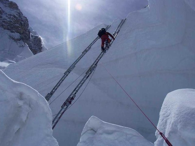 Trying to get through the Khumbu Icefall
(License: CC-BY-2.5]: Wikicommons
 We have to cross it before dawn because at that time, the freezing temperatures help to glue the ice tightly thereby restricting the movement of the icefall. So if you are a deep sleeper, we might as well have to leave you behind here.
It has partially frozen during the night and is less able to move. As the intense sunlight warms the area, the friction between the ice structure lessens and increases the chances of crevasses opening or blocks of snow and ice falling. Source
Upon successfully crossing the Khumbu icefall, we proceed to Camp I above the icefall which is at 6,065 m (19,900 ft). From Camp I, we have to make our way up to Camp II through the glacial valley known as Western Cwm (Cwm, pronounced coom, which is welsh for valley). Also called the “Valley of Silence”, the Western cwm is also another really difficult hurdle to cross when attempting to get to the summit of Everest. This is because of its extremely hot conditions. This could be viewed as ironic considering the extremely cold conditions of Everest.
It was mentioned in the first installment that despite its high elevation of about over 6,000 m, the broad, flat, gently undulating valley reflects solar radiation and cuts off wind due to its bowl-shaped slopes, thereby making it constantly warm, especially on windless days.
Once through the Western cwm, we get to Camp II (also known as the Advance Base Camp) which is at about 6,500 m (21,300 ft) where we face the next challenge of getting to Camp III through the Lhotse Face. We are almost there. The Lhotse Face is a steep-sloped ice wall which is climbed with the use of fixed, interlinked ropes which are permanently in place.
Camp III is located on a small ledge at an altitude of 7,470 m (24,500 ft) above sea level. From there, ropes are also used to climb another 500 m to the last camp, Camp IV (commonly known as the South Col or High Camp) through the Geneva Spur and the Yellow Band.
The Geneva Spur is an anvil shaped rib of black rock named by the 1952 Swiss expedition. Fixed ropes assist climbers in scrambling over this snow covered rock band. The Yellow Band is a section of interlayered marble, phyllite, and semischist, which also requires about 100 metres of rope for traversing it. Source
Upon getting to the High Camp which is at 7,920 m (26,000 m), about 900 m from the summit, we have entered the Death zone. At this point, some of us are supposed to turn back all the way down to the base camp but luckily for us, we just have to keep reading our way through. :D
The Death zone (at above 8,000 m) is the zone of close to zero oxygen for human respiration. Only about 30% of the oxygen that an average person takes at sea level is what is available for climbers in the death zone. A good majority of people who have lost their lives on Everest did so in this treacherous zone and generally, climbers are not expected to last more than two or three days there. This is where climbers have to make the decision whether they really want to risk getting to the summit or not, putting into consideration the available weather and wind conditions as at their time of getting there.
From Camp IV to the summit takes another 900 m and 10 to 12 hours. We first hike to “The Balcony” at 8,440 m (27,700 ft) (above the termination point of the Yellow Band) which serves as small platform where climbers can rest for a while; a much needed breather which we are advised to even take just reading this alone :D.
After which we proceed to the Hillary Step through the South summit and Cornice Traverse, a series of imposing snow and rock steps clinging to each other. The Hillary Step is another imposing 12 m (39 ft) rocky wall at 8,790 m (28, 840 ft). It was named after Edmund Hillary, the first person, along with Sherpa boy Tenzing Norzay, to get to that point and eventually to the summit of the mountain. It is also traversed with the use of fixed ropes such that only once climber and climb it at a time.
The remaining 50 m thereabouts is then hiked to the summit (8,848 m above sea level) from the Hillary Step. Easy as anything right? You are right if you say a blatant No!
Life at the summit – 8,848 is the number to remember forever!
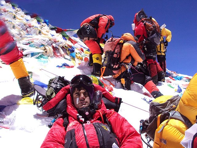 On the Summit of Mount Everest
(License: CC-BY-2.0, Author: Marine-lily]: Wikicommons
 “Started from the Bottom now we here! Started from the bottom now we blah blah blah”. If you came along with your headsets and ear pods, then this popular Drake’s music should be playing in your ears right now. I’m on top of the world by Imagine Dragons is another that should also be on your playlist.
Getting to the top of Mount Everest from the base camp usually takes about 4 days. The same time it would take you to read this article 576 times of you read an average of 2000 words in 10 minutes. Climbers typically spend between half an hour and just over an hour on an average at the summit to take pictures and enjoy the surreal 360 degree view from there before commencing the long but fulfilling journey back to the base camp. What would you do if you were at the highest point on earth?
A Sherpa known as Babu Chiri currently holds the record for the most time spent at the summit, spending just over 21 hours at the top of the mountain. Whatever it is he was doing there for that long is not even as serious a question as how he was able to survive those harsh conditions for that long, alone! Anyway, you could technically beat him to his record by spending at least 22 hours in the section of the article. :D
Here are some other records of people who gotten to the summit of the Sagarmatha;
The fastest ascent from the north side is held by Hans Kammerlander of Italy and took him 16 hours and 45 minutes from Base Camp. The fastest ascent from the South took just under 11 hours and was accomplished by Lakba Gelu Sherpa. Source
To more serious business; It is common to find items such as prayer flags, discarded oxygen containers, cans, crampons and several other expedition equipment close to top of the mountain. This careless disposal of gears and equipment have over time become a nuisance to the mountain environment. Mount Everest has even at some point been referred as the world’s dump site and the Nepalese government have begun to take stringent actions to mitigate the problem. These days, climbers are expected to deposit a certain some of money (about $4,000) before climbing which is only refundable if you return with as much gears and equipment as you went up with. Also;
Expeditions have removed supplies and equipment left by climbers on Everest’s slopes, including hundreds of oxygen containers. A large quantity of the litter of past climbers—tons of items such as tents, cans, crampons, and human waste—has been hauled down from the mountain and recycled or discarded. Source
So you see that bottle of soda you’re are consuming as you read this article, make sure to dispose of it properly and let’s all stop being shitheads. Thank you! :P
References
Mount Everest
Mount Everest. Mountain, Asia
How Climbing Mount Everest Works
How to Climb Mount Everest
Death Zone
This post has been voted on by the steemstem curation team and voting trail.
There is more to SteemSTEM than just writing posts, check here for some more tips on being a community member. You can also join our discord here to get to know the rest of the community!
Downvoting a post can decrease pending rewards and make it less visible. Common reasons:
Submit
Hi @writeit!
Your post was upvoted by utopian.io in cooperation with steemstem - supporting knowledge, innovation and technological advancement on the Steem Blockchain.
Contribute to Open Source with utopian.io
Learn how to contribute on our website and join the new open source economy.
Want to chat? Join the Utopian Community on Discord https://discord.gg/h52nFrV
Downvoting a post can decrease pending rewards and make it less visible. Common reasons:
Submit
Congratulations @writeit! You received a personal award!
You can view your badges on your Steem Board and compare to others on the Steem Ranking
Vote for @Steemitboard as a witness to get one more award and increased upvotes!
Downvoting a post can decrease pending rewards and make it less visible. Common reasons:
Submit