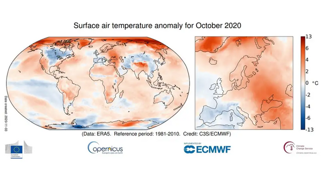
(Image: Copernicus Climate Change Service/ECMWF)
A press release from the Copernicus Program Atmosphere Monitoring Service said that October 2020 was the warmest month in Europe on record since 1981.
Two meteorological indicators became record-breaking: a high average temperature of the surface air layer over continental Europe and a low extent of ice in the Arctic Ocean.
Copernicus is a climate change observing program run by the European Center for Medium-Range Weather Forecasts.
The main task of the program is to analyze data received from satellites, ships, aircraft and weather stations around the world. Based on this analysis, monthly climate bulletins are published.
Recently, scientists from the center reported that the average temperature of the surface air layer over continental Europe within 34-72 degrees north latitude, 25 degrees west longitude and 40 degrees east longitude became the highest in the entire history of observations (since 1981).
The six warmest October on record have occurred in the past six years. At the same time, meteorologists noted the spatial heterogeneity of temperature changes.
The temperature over the Arctic and in the Tibetan plateau region was noticeably higher than the average for the history of observations.
The length of the Arctic sea ice (that is, the percentage of its coverage of the water area of the Arctic Ocean), which became the lowest since 1979, also broke the record.
October was the fourth consecutive month in 2020 that the Northern Sea Route was ice-free. Grim future for the climate and the ecosystems.
Sources: